IMAGES TAKEN NEAR TO
The Folds, HOUGHTON LE SPRING, DH5 9QL
Introduction
This page details the photographs taken nearby to The Folds, DH5 9QL by members of the Geograph project.
The Geograph project started in 2005 with the aim of publishing, organising and preserving representative images for every square kilometre of Great Britain, Ireland and the Isle of Man.

There are currently over 7.5m images from over14,400 individuals and you can help contribute to the project by visiting https://www.geograph.org.uk
Image Map
Images are licensed for reuse under creativecommons.org/licenses/by-sa/2.0
Notes
- Clicking on the map will re-center to the selected point.
- The higher the marker number, the further away the image location is from the centre of the postcode.
Image Listing (30 Images Found)
Images are licensed for reuse under creativecommons.org/licenses/by-sa/2.0
Image
Details
Distance
1
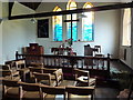
East Rainton Methodist Church, Interior
Image: © Alexander P Kapp
Taken: 22 Aug 2011
0.03 miles
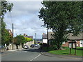
2
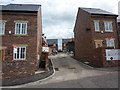
New development off North Street, East Rainton
Image: © Alexander P Kapp
Taken: 22 Aug 2011
0.03 miles
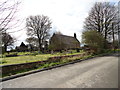
4
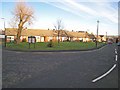
The Folds
Row of bungalows at the top of North Street, East Rainton.
Image: © Oliver Dixon
Taken: 16 Jan 2007
0.04 miles
7
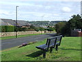
Bench at East Rainton
A bench in the village of East Rainton. The road was once the main road linking Durham with Sunderland, until a by-pass was built. In the distance, the main road can be seen cutting through a hillside above Houghton-le-Spring.
Image: © Malc McDonald
Taken: 28 Aug 2011
0.07 miles
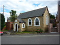
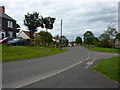
8
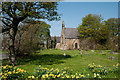
St. Cuthbert's Church and graveyard
St. Cuthbert's Church in East Rainton seen from the south end of the graveyard.
Image: © Trevor Littlewood
Taken: 7 May 2013
0.07 miles
9
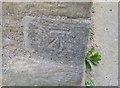
Ordnance Survey Cut Mark
This OS cut mark can be found on the NW face of St Cuthbert's Church. It marks a point 102.724m above mean sea level.
Image: © Adrian Dust
Taken: 20 Sep 2018
0.08 miles