IMAGES TAKEN NEAR TO
Kent Gardens, HOUGHTON LE SPRING, DH5 9LA
Introduction
This page details the photographs taken nearby to Kent Gardens, DH5 9LA by members of the Geograph project.
The Geograph project started in 2005 with the aim of publishing, organising and preserving representative images for every square kilometre of Great Britain, Ireland and the Isle of Man.

There are currently over 7.5m images from over14,400 individuals and you can help contribute to the project by visiting https://www.geograph.org.uk
Image Map
Images are licensed for reuse under creativecommons.org/licenses/by-sa/2.0
Notes
- Clicking on the map will re-center to the selected point.
- The higher the marker number, the further away the image location is from the centre of the postcode.
Image Listing (4 Images Found)
Images are licensed for reuse under creativecommons.org/licenses/by-sa/2.0
Image
Details
Distance
1
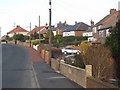
North Road, Hetton-le-Hole
On the B1284 (Fence Houses to Easington Lane) road.
Image: © Oliver Dixon
Taken: 16 Jan 2007
0.17 miles
2
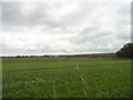
Looking East from the Trail
View from the Great North Forest Trail South of Hazard Lane, looking towards Hetton.
Image: © Robert Graham
Taken: 11 Apr 2012
0.19 miles
3
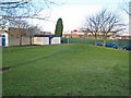
Hetton Schools on Moorsley Road
The Primary School in the foreground, Hetton School (a specialist Technology College) behind. http://www.hetton-school.co.uk/index1.html
Image: © Oliver Dixon
Taken: 16 Jan 2007
0.22 miles
4
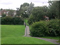
Public Footpath
Path running alongside Alder Close heading back toward town
Image: © Gary Fellows
Taken: 20 Aug 2013
0.23 miles