IMAGES TAKEN NEAR TO
HOUGHTON LE SPRING, DH5 8LU
Introduction
This page details the photographs taken nearby to DH5 8LU by members of the Geograph project.
The Geograph project started in 2005 with the aim of publishing, organising and preserving representative images for every square kilometre of Great Britain, Ireland and the Isle of Man.

There are currently over 7.5m images from over14,400 individuals and you can help contribute to the project by visiting https://www.geograph.org.uk
Image Map
Images are licensed for reuse under creativecommons.org/licenses/by-sa/2.0
Notes
- Clicking on the map will re-center to the selected point.
- The higher the marker number, the further away the image location is from the centre of the postcode.
Image Listing (22 Images Found)
Images are licensed for reuse under creativecommons.org/licenses/by-sa/2.0
Image
Details
Distance
1
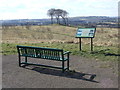
The Copt Hill, near Houghton-le-Spring
The Copt Hill is a pub on the hill overlooking the town of Houghton-le-Spring. On a clear day like this, you can see for miles!
Image: © Malc McDonald
Taken: 30 Mar 2013
0.01 miles
2
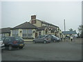
The Copt Hill in Seaham Road, Houghton-le-Spring
Image: © Peter Robinson
Taken: 19 May 2013
0.01 miles
4
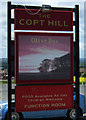
Sign for the Copt Hill pub, near Houghton-le-Spring
Image: © JThomas
Taken: 28 May 2015
0.01 miles
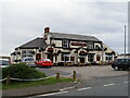
5
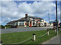
The Copt Hill pub, near Houghton-le-Spring
On Gillas Lane.
Image: © JThomas
Taken: 28 May 2015
0.01 miles
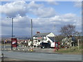
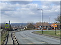
6
Bus stop on Gillas Lane (B1404)
Looking east outside the Copt Hill public house.
Image: © JThomas
Taken: 28 May 2015
0.02 miles
7
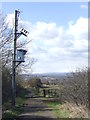
Hetton - Warden Law Trail, near Houghton-le-Spring
As its name suggests, the Hetton - Warden Law Trail links Hetton-le-Hole with Warden Law. Here, it follows the route of the Hetton Colliery Railway which opened in the early 1820s.
The railway was built to carry coal from the mines at Hetton-le-Hole to the port at Sunderland where it could be loaded onto ships. It was the first railway in the world to be designed for locomotives rather than horses, opening about three years before the Stockton & Darlington Railway. However, unlike the Stockton & Darlington Railway, the Hetton Colliery Railway did not carry passengers.
The mine at Hetton-le-Hole closed in 1950. The railway carried on running for another nine years, as it also served several other mines nearby, but it closed in 1959 and was dismantled.
More information about the Hetton Colliery Railway and the mines it served can be found on the Durham Records Online website: http://www.durhamrecordsonline.com/literature/transport.php
Image: © Malc McDonald
Taken: 30 Mar 2013
0.05 miles
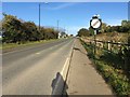
9
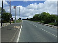
Seaham Road, Houghton-le-Spring
The 30mph speed limit signs indicate that the road is entering a built-up area.
Image: © Malc McDonald
Taken: 30 Mar 2013
0.07 miles