IMAGES TAKEN NEAR TO
Seaham Road, HOUGHTON LE SPRING, DH5 8EB
Introduction
This page details the photographs taken nearby to Seaham Road, DH5 8EB by members of the Geograph project.
The Geograph project started in 2005 with the aim of publishing, organising and preserving representative images for every square kilometre of Great Britain, Ireland and the Isle of Man.

There are currently over 7.5m images from over14,400 individuals and you can help contribute to the project by visiting https://www.geograph.org.uk
Image Map
Images are licensed for reuse under creativecommons.org/licenses/by-sa/2.0
Notes
- Clicking on the map will re-center to the selected point.
- The higher the marker number, the further away the image location is from the centre of the postcode.
Image Listing (17 Images Found)
Images are licensed for reuse under creativecommons.org/licenses/by-sa/2.0
Image
Details
Distance
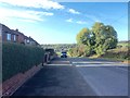
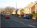
2
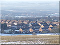
Seaham Road, Houghton-le-Spring
At the elevated south-east corner of the town. On the B1404 Houghton-le-Spring to Seaham road.
Image: © Oliver Dixon
Taken: 16 Jan 2007
0.06 miles
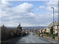
3
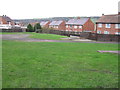
Houghton-le-Spring
Looking over Houghton-le-Spring New Town from Copt Hill
Image: © Malc McDonald
Taken: 28 Dec 2009
0.08 miles
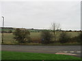
7
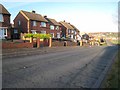
Gillas Lane East, Houghton-le-Spring
Gillas Lane East, looking downhill on a clear morning.
Image: © Malc McDonald
Taken: 30 Mar 2013
0.19 miles
8
Gillas Lane, Houghton-le-Spring
At the elevated south-east corner of the town. On the B1260 Rainton Bridge to Seaham road.
Image: © Oliver Dixon
Taken: 16 Jan 2007
0.19 miles
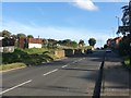
9
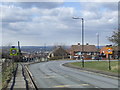
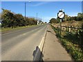
Seaham Road, Houghton-le-Spring
The 30mph speed limit signs indicate that the road is entering a built-up area.
Image: © Malc McDonald
Taken: 30 Mar 2013
0.22 miles