IMAGES TAKEN NEAR TO
Stately Park, HOUGHTON LE SPRING, DH5 0SD
Introduction
This page details the photographs taken nearby to Stately Park, DH5 0SD by members of the Geograph project.
The Geograph project started in 2005 with the aim of publishing, organising and preserving representative images for every square kilometre of Great Britain, Ireland and the Isle of Man.

There are currently over 7.5m images from over14,400 individuals and you can help contribute to the project by visiting https://www.geograph.org.uk
Image Map
Images are licensed for reuse under creativecommons.org/licenses/by-sa/2.0
Notes
- Clicking on the map will re-center to the selected point.
- The higher the marker number, the further away the image location is from the centre of the postcode.
Image Listing (20 Images Found)
Images are licensed for reuse under creativecommons.org/licenses/by-sa/2.0
Image
Details
Distance
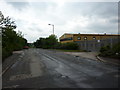
1
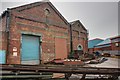
Former Railway Building
Tucked away on the Hetton Lyons Industrial Estate this building was associated with the railway and brickworks. Now a steel stockyard.
Image: © Mick Garratt
Taken: 15 Feb 2014
0.14 miles
2
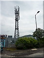
Communication mast, Hetton Lyon Industrial Estate
Image: © Alexander P Kapp
Taken: 26 May 2011
0.14 miles
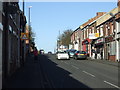
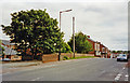
3
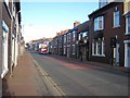
Station Road, Hetton-le-Hole
On the A1052. Like so many others, the station has gone long since.
Image: © Oliver Dixon
Taken: 16 Jan 2007
0.16 miles
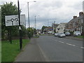
4
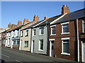
Terraced housing, Station Road, Hetton-le-Hole
Image: © JThomas
Taken: 10 Nov 2012
0.17 miles
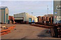
5
Hetton Lyon Industrial Estate
Looking south towards the B1285
Image: © Alexander P Kapp
Taken: 26 May 2011
0.17 miles
6
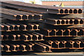
Rail Stockyard
In the grounds of rail manufacturer Trackwork on the Lyons Industrial Estate.
Image: © Mick Garratt
Taken: 16 Feb 2013
0.17 miles
7
Rail Stockyard
Premises of the rail manufacturer Trackwork.
Image: © Mick Garratt
Taken: 16 Feb 2013
0.17 miles
9
Hetton-le-Hole: site of former station
View southward, on the bridge of the A182 (Newcastle - Easington) road over ex-NER (Sunderland) - Murton - Pittington - Durham (Elvet) line. The station had been on the left and was closed to passengers 5/1/53, to goods 11/11/63. Line closures were spread over many years; regular passenger services Pittington - Durham Elvet as early as 1/1/31.
Image: © Ben Brooksbank
Taken: 23 Jun 2002
0.19 miles
10
Colliery Lane in Hetton-le-Hole approaching the junction with Four Lane Ends
Image: © Peter Robinson
Taken: 3 Jun 2012
0.20 miles