IMAGES TAKEN NEAR TO
Wordsworth Avenue, HOUGHTON LE SPRING, DH5 0NR
Introduction
This page details the photographs taken nearby to Wordsworth Avenue, DH5 0NR by members of the Geograph project.
The Geograph project started in 2005 with the aim of publishing, organising and preserving representative images for every square kilometre of Great Britain, Ireland and the Isle of Man.

There are currently over 7.5m images from over14,400 individuals and you can help contribute to the project by visiting https://www.geograph.org.uk
Image Map
Images are licensed for reuse under creativecommons.org/licenses/by-sa/2.0
Notes
- Clicking on the map will re-center to the selected point.
- The higher the marker number, the further away the image location is from the centre of the postcode.
Image Listing (6 Images Found)
Images are licensed for reuse under creativecommons.org/licenses/by-sa/2.0
Image
Details
Distance
2
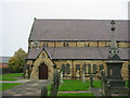
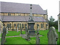
St Michael and All Angels Church Easington Lane
Image: © P Glenwright
Taken: 14 Oct 2006
0.03 miles
3
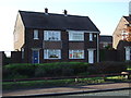
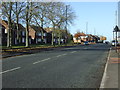
Houses on South Hetton Road, Easington Lane
Image: © JThomas
Taken: 10 Nov 2012
0.04 miles
5
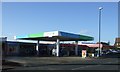
Service station on the A182, Easington Lane
Image: © JThomas
Taken: 10 Nov 2012
0.12 miles
6
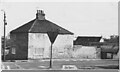
Snippers Gate Farm, Salters Lane
Snippers Gate Farm photographed on 14th February 1974 by Fred Soakell.
South Hetton Colliery pit head can be seen in the background on the left.
The road in the foreground is Salters Lane which leads to Haswell village
Image: © Fred Soakell
Taken: 14 Feb 1974
0.24 miles