IMAGES TAKEN NEAR TO
Bowes Avenue, HOUGHTON LE SPRING, DH5 0HQ
Introduction
This page details the photographs taken nearby to Bowes Avenue, DH5 0HQ by members of the Geograph project.
The Geograph project started in 2005 with the aim of publishing, organising and preserving representative images for every square kilometre of Great Britain, Ireland and the Isle of Man.

There are currently over 7.5m images from over14,400 individuals and you can help contribute to the project by visiting https://www.geograph.org.uk
Image Map
Images are licensed for reuse under creativecommons.org/licenses/by-sa/2.0
Notes
- Clicking on the map will re-center to the selected point.
- The higher the marker number, the further away the image location is from the centre of the postcode.
Image Listing (12 Images Found)
Images are licensed for reuse under creativecommons.org/licenses/by-sa/2.0
Image
Details
Distance
1
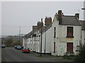
Terraced houses Lyons Lane Hetton le Hole
Image: © P Glenwright
Taken: 14 Oct 2006
0.13 miles
2
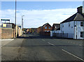
The Bat Cave Easington Lane
Gutted by fire, 9 Jan 1989.
Image: © P Glenwright
Taken: 14 Oct 2006
0.13 miles
4
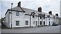
Houses on Lyons Avenue
Lyons Avenue is in the Lyons district of Hetton-Le-Hole; the nameplate on the corner house has the name 'The Lyons'. There's a blue plaque erected by Tyne & Wear County Council, (disbanded in 1986), on that corner house relating to George Stephenson and his brother Robert, who lived in a cottage in the row.
Image: © Trevor Littlewood
Taken: 15 Jun 2021
0.20 miles
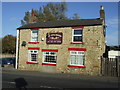
5

Lyons Cottages
Old cottages on Colliery Lane, Hetton-le-Hole. View looking east along the lane.
Image: © Robert Graham
Taken: 3 Jul 2013
0.21 miles
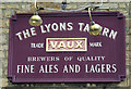
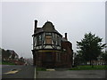
8
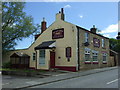
The Lyons Tavern, Hetton-le-Hole
On Four Lane Ends.
Image: © JThomas
Taken: 28 May 2015
0.21 miles