IMAGES TAKEN NEAR TO
Rochdale Street, HOUGHTON LE SPRING, DH5 0BP
Introduction
This page details the photographs taken nearby to Rochdale Street, DH5 0BP by members of the Geograph project.
The Geograph project started in 2005 with the aim of publishing, organising and preserving representative images for every square kilometre of Great Britain, Ireland and the Isle of Man.

There are currently over 7.5m images from over14,400 individuals and you can help contribute to the project by visiting https://www.geograph.org.uk
Image Map
Images are licensed for reuse under creativecommons.org/licenses/by-sa/2.0
Notes
- Clicking on the map will re-center to the selected point.
- The higher the marker number, the further away the image location is from the centre of the postcode.
Image Listing (23 Images Found)
Images are licensed for reuse under creativecommons.org/licenses/by-sa/2.0
Image
Details
Distance
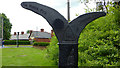
1
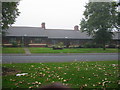
Aged Miners' homes Hetton Le Hole
William Robinson Memorial Homes, built 1918. Aged Miners' Homes like these are to be found throughout the North-east coalfield.
Image: © P Glenwright
Taken: 14 Oct 2006
0.04 miles

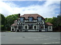
4
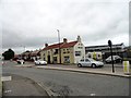
The New Inn at Hetton-le-Hole
At the south end of Station Road, at the junction with Colliery Lane.
Image: © Robert Graham
Taken: 3 Jul 2013
0.15 miles
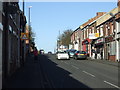
5
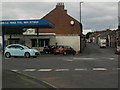
Four Lane Ends Roundabout
North Road running off to the left and Station Road heading straight up
Image: © Gary Fellows
Taken: 29 Aug 2013
0.16 miles
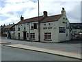
6
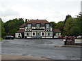
The Fox and Hounds, Hetton-le-Hole
Image: © Alexander P Kapp
Taken: 26 May 2011
0.16 miles