IMAGES TAKEN NEAR TO
Four Lane Ends, HOUGHTON LE SPRING, DH5 0AF
Introduction
This page details the photographs taken nearby to Four Lane Ends, DH5 0AF by members of the Geograph project.
The Geograph project started in 2005 with the aim of publishing, organising and preserving representative images for every square kilometre of Great Britain, Ireland and the Isle of Man.

There are currently over 7.5m images from over14,400 individuals and you can help contribute to the project by visiting https://www.geograph.org.uk
Image Map
Images are licensed for reuse under creativecommons.org/licenses/by-sa/2.0
Notes
- Clicking on the map will re-center to the selected point.
- The higher the marker number, the further away the image location is from the centre of the postcode.
Image Listing (23 Images Found)
Images are licensed for reuse under creativecommons.org/licenses/by-sa/2.0
Image
Details
Distance
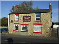
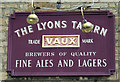
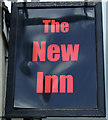
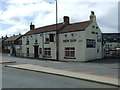
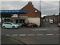
3
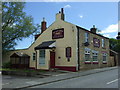
The Lyons Tavern, Hetton-le-Hole
On Four Lane Ends.
Image: © JThomas
Taken: 28 May 2015
0.06 miles
6
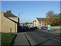
Colliery Lane in Hetton-le-Hole approaching the junction with Four Lane Ends
Image: © Peter Robinson
Taken: 3 Jun 2012
0.09 miles
9
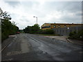
Hetton Lyon Industrial Estate
Looking south towards the B1285
Image: © Alexander P Kapp
Taken: 26 May 2011
0.13 miles
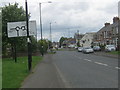
10
Four Lane Ends Roundabout
North Road running off to the left and Station Road heading straight up
Image: © Gary Fellows
Taken: 29 Aug 2013
0.13 miles