IMAGES TAKEN NEAR TO
Maidenhair, HOUGHTON LE SPRING, DH4 7TL
Introduction
This page details the photographs taken nearby to Maidenhair, DH4 7TL by members of the Geograph project.
The Geograph project started in 2005 with the aim of publishing, organising and preserving representative images for every square kilometre of Great Britain, Ireland and the Isle of Man.

There are currently over 7.5m images from over14,400 individuals and you can help contribute to the project by visiting https://www.geograph.org.uk
Image Map
Images are licensed for reuse under creativecommons.org/licenses/by-sa/2.0
Notes
- Clicking on the map will re-center to the selected point.
- The higher the marker number, the further away the image location is from the centre of the postcode.
Image Listing (11 Images Found)
Images are licensed for reuse under creativecommons.org/licenses/by-sa/2.0
Image
Details
Distance
1
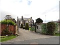
Boundary House, Shiney Row
This large old house is located on Chester Road on the east side of the village. It obviously gives its name to the modern district of Boundary Houses. I don't know its age but it is shown on the Old Series Ordnance Survey map of 1862, and looks to be possibly late 18th century.
Image: © Robert Graham
Taken: 24 Apr 2013
0.13 miles
2
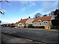
Chester Road, Shiney Row
View of the road near Boundary Houses on the east side of the village. The shop in the picture is Ye Olde Beer Shoppe, an off licence obviously.
Image: © Robert Graham
Taken: 24 Apr 2013
0.14 miles
3
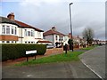
Chester Road, Shiney Row
This is Hindson's Crescent North, running along Chester Road, the main road through the village.
Image: © Robert Graham
Taken: 24 Apr 2013
0.14 miles

5
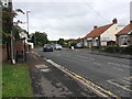
Chester Road
At the junction with Golf Course Road
Image: © Gary Fellows
Taken: 1 Oct 2017
0.15 miles
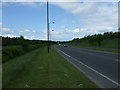
7

Farmland and woodland off the A183
Beside a disused railway.
Image: © JThomas
Taken: 28 May 2015
0.18 miles
8
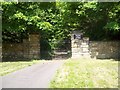
South East Entrance to the Lambton Estate
The path to these gates splits off from the bridle path running through (what is left of) Biddick Woods on the border of the Lambton Estate. These gates lead to Biddick Hall (the home of the Earl of Durham) on his estate, although, like the north gate, they are not in use.
Image: © Craig
Taken: 25 May 2008
0.22 miles
9
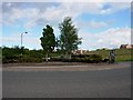
Roundabout on new road
The new road joins the Washington Highway to Chester Road. It was completed in 2004 but the name or designation is unknown to me. A new housing estate is in the background.
Image: © Brian Abbott
Taken: 30 May 2006
0.23 miles
10
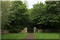
Entrance to Biddick Hall
A notice makes it clear to Weardale Way walkers, and any other pedestrian for that matter - this is not the direction of travel, and keep to the main track.
Image: © Chris Heaton
Taken: 18 May 2023
0.23 miles