IMAGES TAKEN NEAR TO
Bleasdale Crescent, HOUGHTON LE SPRING, DH4 7RH
Introduction
This page details the photographs taken nearby to Bleasdale Crescent, DH4 7RH by members of the Geograph project.
The Geograph project started in 2005 with the aim of publishing, organising and preserving representative images for every square kilometre of Great Britain, Ireland and the Isle of Man.

There are currently over 7.5m images from over14,400 individuals and you can help contribute to the project by visiting https://www.geograph.org.uk
Image Map
Images are licensed for reuse under creativecommons.org/licenses/by-sa/2.0
Notes
- Clicking on the map will re-center to the selected point.
- The higher the marker number, the further away the image location is from the centre of the postcode.
Image Listing (5 Images Found)
Images are licensed for reuse under creativecommons.org/licenses/by-sa/2.0
Image
Details
Distance
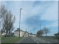
2
The Country Park Inn
Previously under another name, it was renamed in 2004 because it overlooks Herrington Country Park (behind the photographer in this picture). The A183 Sunderland - Chester-le-Street road passes in front of the pub.
Image: © Brian Abbott
Taken: 27 May 2006
0.17 miles
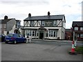
3
Chester Road, Penshaw
Looking west along Victoria Terrace and The Prospect pub in Penshaw. This is a former mining village near Sunderland.
Image: © Robert Graham
Taken: 24 Apr 2013
0.19 miles
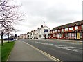
4
Houses on Avondale Avenue, Penshaw
Showing position of Postbox No. DH4 273.
See Image] for postbox.
Image: © JThomas
Taken: 18 Aug 2018
0.21 miles
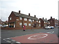
5
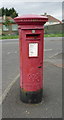
George VI postbox on Wensleydale Avenue, Penshaw
Postbox No. DH4 273.
See Image] for context.
Image: © JThomas
Taken: 18 Aug 2018
0.22 miles