IMAGES TAKEN NEAR TO
Sternboro Park, HOUGHTON LE SPRING, DH4 7PT
Introduction
This page details the photographs taken nearby to Sternboro Park, DH4 7PT by members of the Geograph project.
The Geograph project started in 2005 with the aim of publishing, organising and preserving representative images for every square kilometre of Great Britain, Ireland and the Isle of Man.

There are currently over 7.5m images from over14,400 individuals and you can help contribute to the project by visiting https://www.geograph.org.uk
Image Map (Loading...)


Getting Data...Please wait
Leaflet Map data © OpenStreetMap
Images are licensed for reuse under creativecommons.org/licenses/by-sa/2.0
Notes
- Clicking on the map will re-center to the selected point.
- The higher the marker number, the further away the image location is from the centre of the postcode.
Image Listing (17 Images Found)
Images are licensed for reuse under creativecommons.org/licenses/by-sa/2.0
Image
Details
Distance
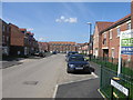
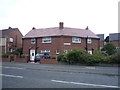
1
Station Road, Penshaw
New Bellway Homes site on the left
Image: © Alex McGregor
Taken: 22 Apr 2010
0.04 miles
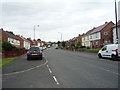
3
Houses on Coxgreen Road / Wensleydale Avenue, Penshaw
Image: © JThomas
Taken: 18 Aug 2018
0.06 miles
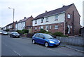
4
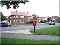
Houses on Coxgreen Road, Penshaw
Showing position of Postbox No. DH4 199.
See Image] for postbox.
Image: © JThomas
Taken: 18 Aug 2018
0.07 miles
5
Elizabeth II postbox on Station Road, Penshaw
Image: © JThomas
Taken: 18 Aug 2018
0.07 miles
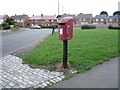
6

Close up, Elizabeth II postbox on Station Road, Penshaw
Postbox No. DH4 199.
See Image] for wider view.
Image: © JThomas
Taken: 18 Aug 2018
0.07 miles
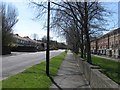
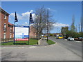
8
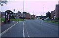
Bus stop and shelter on Station Road, Penshaw
Image: © JThomas
Taken: 18 Aug 2018
0.07 miles