IMAGES TAKEN NEAR TO
Penshaw, HOUGHTON LE SPRING, DH4 7NA
Introduction
This page details the photographs taken nearby to DH4 7NA by members of the Geograph project.
The Geograph project started in 2005 with the aim of publishing, organising and preserving representative images for every square kilometre of Great Britain, Ireland and the Isle of Man.

There are currently over 7.5m images from over14,400 individuals and you can help contribute to the project by visiting https://www.geograph.org.uk
Image Map
Images are licensed for reuse under creativecommons.org/licenses/by-sa/2.0
Notes
- Clicking on the map will re-center to the selected point.
- The higher the marker number, the further away the image location is from the centre of the postcode.
Image Listing (6 Images Found)
Images are licensed for reuse under creativecommons.org/licenses/by-sa/2.0
Image
Details
Distance
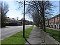
1
The A182 on the outskirts of Shiney Row leading to the roundabout junction with the A183
Image: © Peter Robinson
Taken: 6 May 2013
0.12 miles
2
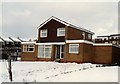
9 Helmsley Close, Shiney Row, Sunderland, 1984
Image: © Martin Routledge
Taken: Unknown
0.14 miles
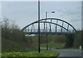
3
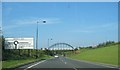
Foot Bridge Near Biddick Hall Roundabout
Approaching the Washington Highway.
Image: © Dianne Snowdon
Taken: 3 Sep 2005
0.21 miles
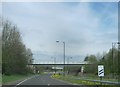
4
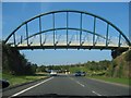
Bridge on Approach to Biddick Hall roundabout
Travelling to Washington.
Image: © Dianne Snowdon
Taken: 3 Sep 2005
0.21 miles