IMAGES TAKEN NEAR TO
Bonaventure, HOUGHTON LE SPRING, DH4 7EP
Introduction
This page details the photographs taken nearby to Bonaventure, DH4 7EP by members of the Geograph project.
The Geograph project started in 2005 with the aim of publishing, organising and preserving representative images for every square kilometre of Great Britain, Ireland and the Isle of Man.

There are currently over 7.5m images from over14,400 individuals and you can help contribute to the project by visiting https://www.geograph.org.uk
Image Map
Images are licensed for reuse under creativecommons.org/licenses/by-sa/2.0
Notes
- Clicking on the map will re-center to the selected point.
- The higher the marker number, the further away the image location is from the centre of the postcode.
Image Listing (8 Images Found)
Images are licensed for reuse under creativecommons.org/licenses/by-sa/2.0
Image
Details
Distance
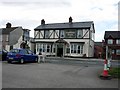
2
Penshaw Village, 2 pubs and a church
Besides the Grey Horse, there is another pub half off the photo to the right. The Church of All Saints was originally erected in 1746.
The old village area is quite upmarket, but close by is a large housing estate originally constructed in the 1920s/1930s for coal miners.
More info: http://www.mymarras.co.uk/pages/penshaw.htm
Image: © Brian Abbott
Taken: 27 May 2006
0.10 miles
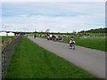
3
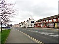
Chester Road, Penshaw
Looking west along Victoria Terrace and The Prospect pub in Penshaw. This is a former mining village near Sunderland.
Image: © Robert Graham
Taken: 24 Apr 2013
0.15 miles
4
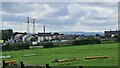
Herrington Country Park
The site of Herrington Colliery which closed in 1985. Today the venue for the 2011 North of England Cross Country Championships.
Image: © Mick Garratt
Taken: 29 Jan 2011
0.16 miles
5
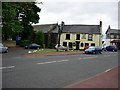
The Country Park Inn
Previously under another name, it was renamed in 2004 because it overlooks Herrington Country Park (behind the photographer in this picture). The A183 Sunderland - Chester-le-Street road passes in front of the pub.
Image: © Brian Abbott
Taken: 27 May 2006
0.16 miles
6
Entrance to Herrington Country Park
Herrington Country Park was opened in 2003 on the site of a former colliery and opencast mine. What was once an eyesore with a very large slagheap is being transformed (trees take time to grow!) into a large pleasant leisure area.
Image: © Brian Abbott
Taken: 21 May 2006
0.22 miles
7

Visitor Centre at Herrington Country Park
Image: © Peter Robinson
Taken: 6 May 2013
0.23 miles
8

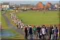
View SW from Penshaw Hill
Views from this 450 foot hill near Sunderland are outstanding. Here the view is over Penshaw and the surrounding villages to the foothills of the Pennines a long way in the distance.
Image: © Robert Graham
Taken: 24 Apr 2013
0.24 miles