IMAGES TAKEN NEAR TO
Chingford Close, HOUGHTON LE SPRING, DH4 7ED
Introduction
This page details the photographs taken nearby to Chingford Close, DH4 7ED by members of the Geograph project.
The Geograph project started in 2005 with the aim of publishing, organising and preserving representative images for every square kilometre of Great Britain, Ireland and the Isle of Man.

There are currently over 7.5m images from over14,400 individuals and you can help contribute to the project by visiting https://www.geograph.org.uk
Image Map
Images are licensed for reuse under creativecommons.org/licenses/by-sa/2.0
Notes
- Clicking on the map will re-center to the selected point.
- The higher the marker number, the further away the image location is from the centre of the postcode.
Image Listing (3 Images Found)
Images are licensed for reuse under creativecommons.org/licenses/by-sa/2.0
Image
Details
Distance
2
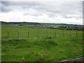
Herrington Country Park and New Herrington village
The South-Western part of Herrington Country Park is in the foreground. In the distance is New Herrington village (an ex pit-village).
Image: © Brian Abbott
Taken: 27 May 2006
0.22 miles
3
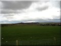
View across the Country Park from Chester Road, Penshaw
Looking SE towards the woods on Herrington Hill in the distance. The Country Park was created from the former site of Herrington Colliery.
Image: © Robert Graham
Taken: 24 Apr 2013
0.23 miles