IMAGES TAKEN NEAR TO
Chester Road, HOUGHTON LE SPRING, DH4 7DJ
Introduction
This page details the photographs taken nearby to Chester Road, DH4 7DJ by members of the Geograph project.
The Geograph project started in 2005 with the aim of publishing, organising and preserving representative images for every square kilometre of Great Britain, Ireland and the Isle of Man.

There are currently over 7.5m images from over14,400 individuals and you can help contribute to the project by visiting https://www.geograph.org.uk
Image Map
Images are licensed for reuse under creativecommons.org/licenses/by-sa/2.0
Notes
- Clicking on the map will re-center to the selected point.
- The higher the marker number, the further away the image location is from the centre of the postcode.
Image Listing (6 Images Found)
Images are licensed for reuse under creativecommons.org/licenses/by-sa/2.0
Image
Details
Distance
1
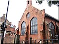
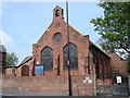
St Oswald's Church, Shiney Row
This C of E church was built in 1909 to cater for the miners who were working in the nearby collieries. Designed by C H Fowler , architect of Durham.
Image: © Robert Graham
Taken: 15 Aug 2023
0.22 miles
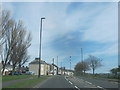
2
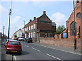
The Travellers Rest, Shiney Row
On Mill Terrace (A182).
Image: © JThomas
Taken: 28 May 2015
0.22 miles
4
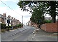
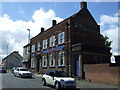
Philadelphia Road in Shiney Row
Early 20th century terraced houses in this former mining village.
Image: © Robert Graham
Taken: 15 Aug 2023
0.23 miles