IMAGES TAKEN NEAR TO
Middle Rainton, HOUGHTON LE SPRING, DH4 6PL
Introduction
This page details the photographs taken nearby to DH4 6PL by members of the Geograph project.
The Geograph project started in 2005 with the aim of publishing, organising and preserving representative images for every square kilometre of Great Britain, Ireland and the Isle of Man.

There are currently over 7.5m images from over14,400 individuals and you can help contribute to the project by visiting https://www.geograph.org.uk
Image Map
Images are licensed for reuse under creativecommons.org/licenses/by-sa/2.0
Notes
- Clicking on the map will re-center to the selected point.
- The higher the marker number, the further away the image location is from the centre of the postcode.
Image Listing (6 Images Found)
Images are licensed for reuse under creativecommons.org/licenses/by-sa/2.0
Image
Details
Distance
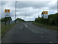
1
Bus stop on the A690
Approaching the turn off for East Rainton.
Image: © JThomas
Taken: 28 May 2015
0.11 miles

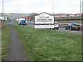
3
Entering The City of Sunderland
Heading north east on the A690.
Image: © JThomas
Taken: 28 May 2015
0.13 miles
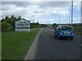
4
Sunderland boundary on the A690
The escarpment behind Houghton-le-Spring Image can be seen on the horizon.
Image: © Oliver Dixon
Taken: 2 Mar 2007
0.14 miles
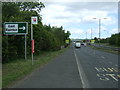
5
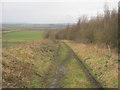
Permissive path down from the A690 at Middle Rainton
Image: © Peter Robinson
Taken: 10 Feb 2013
0.19 miles