IMAGES TAKEN NEAR TO
West Rainton, HOUGHTON LE SPRING, DH4 6NT
Introduction
This page details the photographs taken nearby to DH4 6NT by members of the Geograph project.
The Geograph project started in 2005 with the aim of publishing, organising and preserving representative images for every square kilometre of Great Britain, Ireland and the Isle of Man.

There are currently over 7.5m images from over14,400 individuals and you can help contribute to the project by visiting https://www.geograph.org.uk
Image Map
Images are licensed for reuse under creativecommons.org/licenses/by-sa/2.0
Notes
- Clicking on the map will re-center to the selected point.
- The higher the marker number, the further away the image location is from the centre of the postcode.
Image Listing (27 Images Found)
Images are licensed for reuse under creativecommons.org/licenses/by-sa/2.0
Image
Details
Distance
1
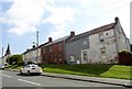
South Street, West Rainton
View along the village main street, looking east. The tall spire of St Mary's church visible on the right.
Image: © Robert Graham
Taken: 20 Apr 2016
0.05 miles
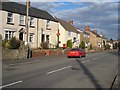
3
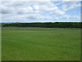
Mark's Lane
Heading south east towards West Rainton.
Image: © JThomas
Taken: 28 May 2015
0.13 miles
4
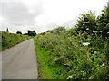
Wild flowers along Mark's Lane
Looking south along the lane to the village of West Rainton. The verges are full of wild flowers at this time in early summer. Prominent are the blue flowers of Meadow Cranesbill and the white flowers of several different Umbellifers. Hogweed and some others I can't identify. Cow Parsley is now out of flower; seed heads can be seen.
Image: © Robert Graham
Taken: 3 Jul 2013
0.14 miles
5
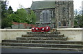
War Memorial, West Rainton
In front of St Mary the Virgin Church.
Image: © JThomas
Taken: 28 May 2015
0.14 miles
7
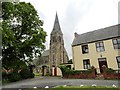
St Mary the Virgin church
At West Rainton, a village near Durham. The church dates from 1864, when the village was expanding with miners for the local pits. The spire, at 130 feet high, is a prominent local landmark.
Image: © Robert Graham
Taken: 3 Jul 2013
0.15 miles
8
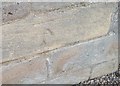
Ordnance Survey Cut Mark
This OS cut mark can be found on the west face of St Mary's Church. It marks a point 91.800m above mean sea level.
Image: © Adrian Dust
Taken: 16 Sep 2018
0.15 miles
9
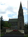
St Mary the Virgin Church, West Rainton
War Memorial in front.
Image: © JThomas
Taken: 28 May 2015
0.15 miles
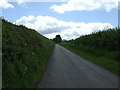
10
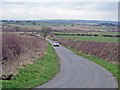
Mark's Lane, West Rainton
The tower blocks on the south side of Gateshead can be seen on the horizon.
Image: © Oliver Dixon
Taken: 2 Mar 2007
0.15 miles