IMAGES TAKEN NEAR TO
Masons Court, HOUGHTON LE SPRING, DH4 6FS
Introduction
This page details the photographs taken nearby to Masons Court, DH4 6FS by members of the Geograph project.
The Geograph project started in 2005 with the aim of publishing, organising and preserving representative images for every square kilometre of Great Britain, Ireland and the Isle of Man.

There are currently over 7.5m images from over14,400 individuals and you can help contribute to the project by visiting https://www.geograph.org.uk
Image Map
Images are licensed for reuse under creativecommons.org/licenses/by-sa/2.0
Notes
- Clicking on the map will re-center to the selected point.
- The higher the marker number, the further away the image location is from the centre of the postcode.
Image Listing (22 Images Found)
Images are licensed for reuse under creativecommons.org/licenses/by-sa/2.0
Image
Details
Distance
1

Fire damaged pub, Rainton Gate
What is left of the Masons Arms.
See Image for better times.
Image: © JThomas
Taken: 28 May 2015
0.01 miles
2

The Masons Arms, West Rainton
The Masons Arms, a pub in the village of West Rainton, County Durham.
Image: © Malc McDonald
Taken: 28 Aug 2011
0.01 miles
3
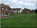
Houses in West Rainton
A housing estate in West Rainton, designed around green space.
Image: © Malc McDonald
Taken: 28 Aug 2011
0.01 miles

5
View of Rainton Gate
The Masons Arm in the centre of the picture, on a rather wet morning.
Image: © Robert Graham
Taken: 11 Apr 2012
0.02 miles
6
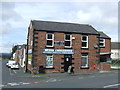
Local shop, West Rainton
A local shop in West Rainton, County Durham. West Rainton lies on a hillside roughly 100 metres above sea level.
Image: © Malc McDonald
Taken: 28 Aug 2011
0.04 miles
7
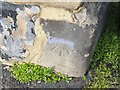
Ordnance Survey Cut Mark
This OS cut mark can be found on the SW face of Gate House. It marks a point 91.909m above mean sea level.
Image: © Adrian Dust
Taken: 16 Sep 2018
0.04 miles
8

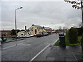
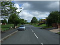
Road entering Rainton Gate
Rainton Gate is a village of County Durham North-east of the city of Durham; the road enters the south end of the village. The blue and yellow road sign is in a style introduced in the county some years ago.
Image: © Trevor Littlewood
Taken: 7 May 2013
0.07 miles

10
Chantry Place, Rainton Gate
Heading north east.
Image: © JThomas
Taken: 28 May 2015
0.07 miles