IMAGES TAKEN NEAR TO
Medwyn Close, HOUGHTON LE SPRING, DH4 6ES
Introduction
This page details the photographs taken nearby to Medwyn Close, DH4 6ES by members of the Geograph project.
The Geograph project started in 2005 with the aim of publishing, organising and preserving representative images for every square kilometre of Great Britain, Ireland and the Isle of Man.

There are currently over 7.5m images from over14,400 individuals and you can help contribute to the project by visiting https://www.geograph.org.uk
Image Map
Images are licensed for reuse under creativecommons.org/licenses/by-sa/2.0
Notes
- Clicking on the map will re-center to the selected point.
- The higher the marker number, the further away the image location is from the centre of the postcode.
Image Listing (11 Images Found)
Images are licensed for reuse under creativecommons.org/licenses/by-sa/2.0
Image
Details
Distance
1
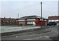
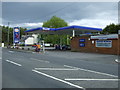
Shops and Post Office
on Marigold Crescent, Bournmoor, County Durham
Image: © Chris Tweedy
Taken: 30 Jan 2006
0.17 miles
4
The Disused Lambton Railway Lumley Branch Line
The track has long disappeared, and is now utilised as part of the Weardale Way long distance footpath
Image: © Chris Heaton
Taken: 18 May 2023
0.20 miles
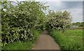
5
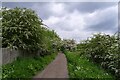
The Weardale Way leaving New Lambton
Following the track of the old Lambton Railway. The hawthorn seems to be flowering a little later this year.
Image: © Tim Heaton
Taken: 18 May 2023
0.20 miles
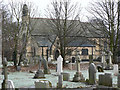
6
St. Barnabas's Church, Burnmoor Parish
Image: © Bill Henderson
Taken: 27 Apr 2007
0.21 miles
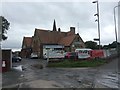
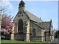
7
The Church of St. Barnabas
Built in 1867-1868, the church is in the village of Bournmoor in County Durham.
Photographed on a cold and frosty morning in late January 2006
Image: © Chris Tweedy
Taken: 30 Jan 2006
0.21 miles
8
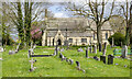
Church of St. Barnabas, Bournmoor
The brick-built church has associations with the Lambton family of the adjacent Lambton Castle estate. The tall, Lambton Memorial Cross can be seen just to the right of the porch. The graveyard is open and rather unkempt with many gravestones pitched away from the vertical, perhaps due to mining subsidence.
Image: © Trevor Littlewood
Taken: 25 Apr 2023
0.22 miles
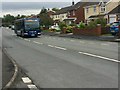
10
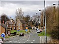
Chapel Row, Bournmoor
Bournmoor is a little former mining village near Fence Houses. It does have some nice old houses.
Image: © Robert Graham
Taken: 24 Apr 2013
0.24 miles