IMAGES TAKEN NEAR TO
Ellesmere, HOUGHTON LE SPRING, DH4 6DZ
Introduction
This page details the photographs taken nearby to Ellesmere, DH4 6DZ by members of the Geograph project.
The Geograph project started in 2005 with the aim of publishing, organising and preserving representative images for every square kilometre of Great Britain, Ireland and the Isle of Man.

There are currently over 7.5m images from over14,400 individuals and you can help contribute to the project by visiting https://www.geograph.org.uk
Image Map
Images are licensed for reuse under creativecommons.org/licenses/by-sa/2.0
Notes
- Clicking on the map will re-center to the selected point.
- The higher the marker number, the further away the image location is from the centre of the postcode.
Image Listing (19 Images Found)
Images are licensed for reuse under creativecommons.org/licenses/by-sa/2.0
Image
Details
Distance
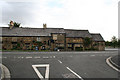
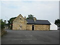
1
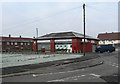
Shops and Post Office
on Marigold Crescent, Bournmoor, County Durham
Image: © Chris Tweedy
Taken: 30 Jan 2006
0.09 miles
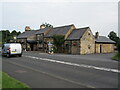
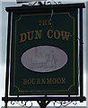
6
The Dun Cow
The Dun Cow Public house near Houghton Gate
Image: © Colin Keightley
Taken: 27 Aug 2005
0.14 miles
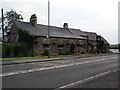
7
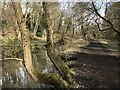
Woodland path beside Lumley Park Burn
Image: © David Robinson
Taken: 14 Mar 2023
0.14 miles
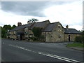
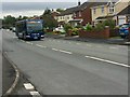
10

Following Lumley Park Burn towards Bournmoor
Near the end of the Weardale Way's 2 mile route along the Burn
Image: © Tim Heaton
Taken: 18 May 2023
0.16 miles