IMAGES TAKEN NEAR TO
New Lambton, HOUGHTON LE SPRING, DH4 6DD
Introduction
This page details the photographs taken nearby to DH4 6DD by members of the Geograph project.
The Geograph project started in 2005 with the aim of publishing, organising and preserving representative images for every square kilometre of Great Britain, Ireland and the Isle of Man.

There are currently over 7.5m images from over14,400 individuals and you can help contribute to the project by visiting https://www.geograph.org.uk
Image Map
Images are licensed for reuse under creativecommons.org/licenses/by-sa/2.0
Notes
- Clicking on the map will re-center to the selected point.
- The higher the marker number, the further away the image location is from the centre of the postcode.
Image Listing (14 Images Found)
Images are licensed for reuse under creativecommons.org/licenses/by-sa/2.0
Image
Details
Distance
1
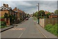
Lambton Lane
Leading into the community of New Lambton, as seen from where the lane is crossed by the Weardale Way
Image: © Chris Heaton
Taken: 18 May 2023
0.07 miles
2
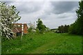
The Weardale Way following the route of the old Lambton Railway
The post gives information on the line, which was built as a waggonway in 1791 before the use of steam engines.
Image: © Tim Heaton
Taken: 18 May 2023
0.07 miles
3

Signpost detailing former railways and collieries in the Lambton area
Image: © David Robinson
Taken: 14 Mar 2023
0.10 miles
4

The Disused Lambton Railway Lumley Branch Line
The track has long disappeared, and is now utilised as part of the Weardale Way long distance footpath
Image: © Chris Heaton
Taken: 18 May 2023
0.10 miles
5
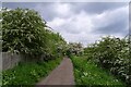
The Weardale Way leaving New Lambton
Following the track of the old Lambton Railway. The hawthorn seems to be flowering a little later this year.
Image: © Tim Heaton
Taken: 18 May 2023
0.10 miles
6
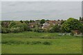
New Lambton as seen from the A1052
Scene witnessed from the Weardale Way
Image: © Chris Heaton
Taken: 18 May 2023
0.16 miles
7
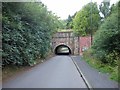
Old Railway Bridge
Bridge crossing over Lambton Lane
Image: © Gary Fellows
Taken: 9 Sep 2016
0.20 miles

9

The Floaters Mill
The original mill dated back to at least the 17th century, then became a farm, and then a public house in 1982. The origin of the name is uncertain https://sites.google.com/site/allthingsbournmoor/floaters-mill
Image: © Tim Heaton
Taken: 18 May 2023
0.24 miles
10
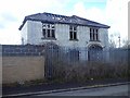
Derelict House
Just before the bridge on Lambton Lane
Image: © Gary Fellows
Taken: 30 Apr 2016
0.24 miles