IMAGES TAKEN NEAR TO
Newcastle Road, HOUGHTON LE SPRING, DH4 5PX
Introduction
This page details the photographs taken nearby to Newcastle Road, DH4 5PX by members of the Geograph project.
The Geograph project started in 2005 with the aim of publishing, organising and preserving representative images for every square kilometre of Great Britain, Ireland and the Isle of Man.

There are currently over 7.5m images from over14,400 individuals and you can help contribute to the project by visiting https://www.geograph.org.uk
Image Map
Images are licensed for reuse under creativecommons.org/licenses/by-sa/2.0
Notes
- Clicking on the map will re-center to the selected point.
- The higher the marker number, the further away the image location is from the centre of the postcode.
Image Listing (10 Images Found)
Images are licensed for reuse under creativecommons.org/licenses/by-sa/2.0
Image
Details
Distance
1
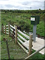
River level recorder near Houghton-le-Spring
A recording device measuring the water level of Moors Burn, a small river which is a tributary of the River Wear.
Image: © Malc McDonald
Taken: 29 Aug 2011
0.03 miles
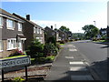

9
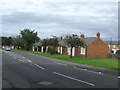
Bungalows near Houghton-le-Spring
Bungalows on Dairy Lane, near Houghton-le-Spring.
Image: © Malc McDonald
Taken: 29 Aug 2011
0.21 miles