IMAGES TAKEN NEAR TO
Fencehouses, HOUGHTON LE SPRING, DH4 5PN
Introduction
This page details the photographs taken nearby to DH4 5PN by members of the Geograph project.
The Geograph project started in 2005 with the aim of publishing, organising and preserving representative images for every square kilometre of Great Britain, Ireland and the Isle of Man.

There are currently over 7.5m images from over14,400 individuals and you can help contribute to the project by visiting https://www.geograph.org.uk
Image Map
Images are licensed for reuse under creativecommons.org/licenses/by-sa/2.0
Notes
- Clicking on the map will re-center to the selected point.
- The higher the marker number, the further away the image location is from the centre of the postcode.
Image Listing (17 Images Found)
Images are licensed for reuse under creativecommons.org/licenses/by-sa/2.0
Image
Details
Distance
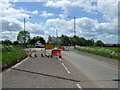
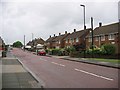
3
Sedgeletch Road
Looking back toward Sedgeletch Road from Blind Lane
Image: © Gary Fellows
Taken: 19 Jan 2013
0.10 miles
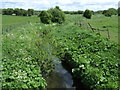
4
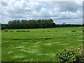
Grazing off Sedgeletch Road
Near the Moors Burn.
Image: © JThomas
Taken: 28 May 2015
0.11 miles
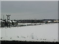
5
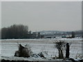
Sewage Works
Looking back toward the sewage works from Blind Lane
Image: © Gary Fellows
Taken: 17 Jan 2013
0.14 miles
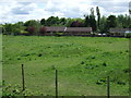
6
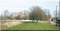
Grassed area on west side of Sedgeletch Road
Sedgeletch Road runs north from Fence Houses. The grassed area is probably to be regarded as an extra-wide grass verge!
Image: © Trevor Littlewood
Taken: 20 Feb 2018
0.16 miles
7
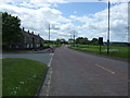
Sedgeletch Road, Burnside
Heading south west.
Image: © JThomas
Taken: 28 May 2015
0.17 miles
10

Blind Lane
Heading north west towards Shiney Row.
Image: © JThomas
Taken: 28 May 2015
0.21 miles