IMAGES TAKEN NEAR TO
Stoneygate, HOUGHTON LE SPRING, DH4 4NN
Introduction
This page details the photographs taken nearby to DH4 4NN by members of the Geograph project.
The Geograph project started in 2005 with the aim of publishing, organising and preserving representative images for every square kilometre of Great Britain, Ireland and the Isle of Man.

There are currently over 7.5m images from over14,400 individuals and you can help contribute to the project by visiting https://www.geograph.org.uk
Image Map
Images are licensed for reuse under creativecommons.org/licenses/by-sa/2.0
Notes
- Clicking on the map will re-center to the selected point.
- The higher the marker number, the further away the image location is from the centre of the postcode.
Image Listing (3 Images Found)
Images are licensed for reuse under creativecommons.org/licenses/by-sa/2.0
Image
Details
Distance
1
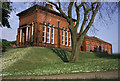
Stonygate Pumping Station
Former steam powered water pumping station of the Sunderland & South Shields Water Company. There used to be the remains of a steam winch in a separate building (the roof is just visible to the left of the main entrance) but this has now been scrapped. There are several fine pumping stations in the north-east, including Ryhope.
Image: © Chris Allen
Taken: 27 May 1989
0.11 miles
2
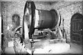
Stonygate Pumping Station, steam winch
Horizontal single cylinder worm geared winch built c1900 by the Birtley Iron Co.
It was used as necessary for well maintenance until about 1959. When seen in 1984 it was part dismantled and it is believed the remains were scrapped between 1985 and 1995 (based on observations from infrequent visits). This was housed in a pretty little winch house adjoining the main pumping station.
Image: © Chris Allen
Taken: 27 Nov 1984
0.12 miles