IMAGES TAKEN NEAR TO
Lambton Park, CHESTER LE STREET, DH3 4PX
Introduction
This page details the photographs taken nearby to DH3 4PX by members of the Geograph project.
The Geograph project started in 2005 with the aim of publishing, organising and preserving representative images for every square kilometre of Great Britain, Ireland and the Isle of Man.

There are currently over 7.5m images from over14,400 individuals and you can help contribute to the project by visiting https://www.geograph.org.uk
Image Map (Loading...)


Getting Data...Please wait
Leaflet Map data © OpenStreetMap
Images are licensed for reuse under creativecommons.org/licenses/by-sa/2.0
Notes
- Clicking on the map will re-center to the selected point.
- The higher the marker number, the further away the image location is from the centre of the postcode.
Image Listing (8 Images Found)
Images are licensed for reuse under creativecommons.org/licenses/by-sa/2.0
Image
Details
Distance
1
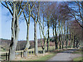
Trees lining road on Lambton Estate
The trees and road lie beyond a hefty gate at the east end of Chester Bridge over the River Wear.
Image: © Trevor Littlewood
Taken: 23 Mar 2018
0.02 miles
2
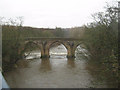
Chester New Bridge for the western gate to Lambton Castle
Image: © Peter Robinson
Taken: 13 Feb 2011
0.02 miles
3
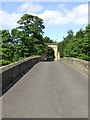
West entrance gate to Lambton Estate
The entrance is at the end of a (private) stone bridge over the River Wear.
Image: © Brian Abbott
Taken: 29 May 2006
0.06 miles
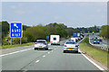
5

Chester-le-Street : A1(M) Junction 63
At Junction 63, Blind Lane.
Image: © Lewis Clarke
Taken: 21 Sep 2020
0.22 miles
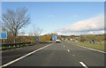
6
Northbound A1(M) at Junction 63 (Blind Lane Interchange)
Image: © David Dixon
Taken: 29 Apr 2019
0.23 miles
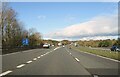
8
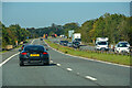
Chester-le-Street : A1(M)
Looking north on the A1(M).
Image: © Lewis Clarke
Taken: 21 Sep 2020
0.24 miles