IMAGES TAKEN NEAR TO
Harraton Terrace, CHESTER LE STREET, DH3 4PP
Introduction
This page details the photographs taken nearby to Harraton Terrace, DH3 4PP by members of the Geograph project.
The Geograph project started in 2005 with the aim of publishing, organising and preserving representative images for every square kilometre of Great Britain, Ireland and the Isle of Man.

There are currently over 7.5m images from over14,400 individuals and you can help contribute to the project by visiting https://www.geograph.org.uk
Image Map
Images are licensed for reuse under creativecommons.org/licenses/by-sa/2.0
Notes
- Clicking on the map will re-center to the selected point.
- The higher the marker number, the further away the image location is from the centre of the postcode.
Image Listing (4 Images Found)
Images are licensed for reuse under creativecommons.org/licenses/by-sa/2.0
Image
Details
Distance
1
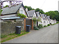
Houses near Lambton Castle
A terrace of houses (almost certainly former estate houses on the Lambton Castle estate) situated on what is clearly an old road from Chartershaugh to General's Wood. It is not obvious whether the outhouses are privies or coalsheds - or both.
Image: © Oliver Dixon
Taken: 19 Jun 2015
0.01 miles
2
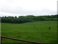
Cattle in a field on Lord Lambton's Estate
Image: © Brian Abbott
Taken: 27 May 2006
0.20 miles
3
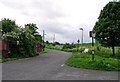
No Entry signs bar entry to the Lambton Estate
Rather incongruously stuck on the outskirts of Washington is the estate (and castle!) of Lord Lambton. Although bits have been sold off over the years, it still occupies an area of around 3 km2. Here at the Eastern end the road leads into the estate but No Entry signs bar the way.
Image: © Brian Abbott
Taken: 27 May 2006
0.21 miles
4
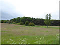
The General's Wood
The General's Wood is the name given to both this wood and the "posh" part of Washington New Town to the north.
Image: © Oliver Dixon
Taken: 19 Jun 2015
0.24 miles