IMAGES TAKEN NEAR TO
Houghton Gate, CHESTER LE STREET, DH3 4PD
Introduction
This page details the photographs taken nearby to Houghton Gate, DH3 4PD by members of the Geograph project.
The Geograph project started in 2005 with the aim of publishing, organising and preserving representative images for every square kilometre of Great Britain, Ireland and the Isle of Man.

There are currently over 7.5m images from over14,400 individuals and you can help contribute to the project by visiting https://www.geograph.org.uk
Image Map
Images are licensed for reuse under creativecommons.org/licenses/by-sa/2.0
Notes
- Clicking on the map will re-center to the selected point.
- The higher the marker number, the further away the image location is from the centre of the postcode.
Image Listing (9 Images Found)
Images are licensed for reuse under creativecommons.org/licenses/by-sa/2.0
Image
Details
Distance
1
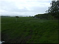
Grazing, Houghton Gate
The A183 in the distance.
Image: © JThomas
Taken: 28 May 2015
0.05 miles
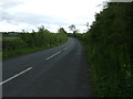

4
Approaching the A183
Heading north west on the A1052.
Image: © JThomas
Taken: 28 May 2015
0.10 miles
6
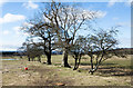
Line of deciduous trees crossing field
OS mapping indicates a field boundary along the line of the trees and so it's assumed that they were once part of a hedge which have been allowed to overgrow!
Image: © Trevor Littlewood
Taken: 23 Mar 2018
0.14 miles
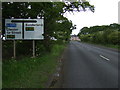
7
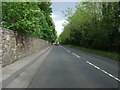
Chester Road (A183)
Heading east towards Sunderland.
Image: © JThomas
Taken: 28 May 2015
0.16 miles

9
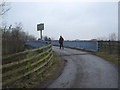
Bridge carrying Weardale Way footpath over the A1(M)
Image: © Peter Robinson
Taken: 13 Feb 2011
0.22 miles