IMAGES TAKEN NEAR TO
Tintagel, CHESTER LE STREET, DH3 4NF
Introduction
This page details the photographs taken nearby to Tintagel, DH3 4NF by members of the Geograph project.
The Geograph project started in 2005 with the aim of publishing, organising and preserving representative images for every square kilometre of Great Britain, Ireland and the Isle of Man.

There are currently over 7.5m images from over14,400 individuals and you can help contribute to the project by visiting https://www.geograph.org.uk
Image Map
Images are licensed for reuse under creativecommons.org/licenses/by-sa/2.0
Notes
- Clicking on the map will re-center to the selected point.
- The higher the marker number, the further away the image location is from the centre of the postcode.
Image Listing (8 Images Found)
Images are licensed for reuse under creativecommons.org/licenses/by-sa/2.0
Image
Details
Distance
2
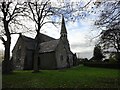
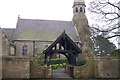
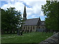
Christ Church, Great Lumley
Prior to 1858, Great Lumley was part of Chester-Le-Street parish, but a new parish was created then. This was due to the large increase in population which followed from the opening of new coal mines in the area. The new parish church was built in 1859 to a design by M Thompson, architect of Newcastle, in neo-gothic style.
Image: © Robert Graham
Taken: 13 Nov 2013
0.20 miles

6
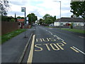
Bus stop on Front Street, Great Lumley
Looking west.
Image: © JThomas
Taken: 28 May 2015
0.21 miles
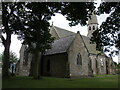
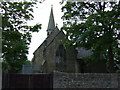
7
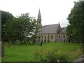
Christ Church at Great Lumley
In County Durham.
Image: © James Denham
Taken: 27 Jun 2014
0.22 miles