IMAGES TAKEN NEAR TO
Runnymede, CHESTER LE STREET, DH3 4LW
Introduction
This page details the photographs taken nearby to Runnymede, DH3 4LW by members of the Geograph project.
The Geograph project started in 2005 with the aim of publishing, organising and preserving representative images for every square kilometre of Great Britain, Ireland and the Isle of Man.

There are currently over 7.5m images from over14,400 individuals and you can help contribute to the project by visiting https://www.geograph.org.uk
Image Map
Images are licensed for reuse under creativecommons.org/licenses/by-sa/2.0
Notes
- Clicking on the map will re-center to the selected point.
- The higher the marker number, the further away the image location is from the centre of the postcode.
Image Listing (4 Images Found)
Images are licensed for reuse under creativecommons.org/licenses/by-sa/2.0
Image
Details
Distance
1
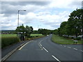
Bus stop and shelter on Back Lane, Great Lumley
Looking north.
Image: © JThomas
Taken: 28 May 2015
0.12 miles
2
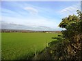
View northwest from Back Lane, Great Lumley
Great Lumley lies on a spur of high ground east of the River Wear and affords extensive views over the countryside south of Chester-Le-Street.
Image: © Robert Graham
Taken: 13 Nov 2013
0.17 miles
3
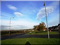
Looking north up Back Lane, Great Lumley
This road skirts the western side of the village. The houses on the right are part of the extensive modern estates which have been built on the north side of this ancient village. In the distance are extensive views over Lumley Castle and Gateshead on the far horizon.
Image: © Robert Graham
Taken: 13 Nov 2013
0.18 miles