IMAGES TAKEN NEAR TO
Napier Close, CHESTER LE STREET, DH3 4BN
Introduction
This page details the photographs taken nearby to Napier Close, DH3 4BN by members of the Geograph project.
The Geograph project started in 2005 with the aim of publishing, organising and preserving representative images for every square kilometre of Great Britain, Ireland and the Isle of Man.

There are currently over 7.5m images from over14,400 individuals and you can help contribute to the project by visiting https://www.geograph.org.uk
Image Map
Images are licensed for reuse under creativecommons.org/licenses/by-sa/2.0
Notes
- Clicking on the map will re-center to the selected point.
- The higher the marker number, the further away the image location is from the centre of the postcode.
Image Listing (17 Images Found)
Images are licensed for reuse under creativecommons.org/licenses/by-sa/2.0
Image
Details
Distance
1
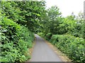
Former mineral railway
Now a foot/cycle path.
Image: © Richard Webb
Taken: 18 Jun 2013
0.06 miles
2
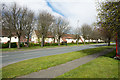
Houses at Barley Mow
The semi-detached homes are at the south side of Vigo Lane and are in the Barley Mow district of Birtley. The boundary between County Durham and the Metropolitan Borough of Gateshead runs along the centre of Vigo Lane.
Image: © Trevor Littlewood
Taken: 25 Apr 2016
0.22 miles
3
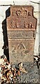
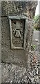
Edward VII GPO cable marker against boundary wall of Grange Cottages, Durham Road
See https://gpo-markers.derektp.co.uk/detail?post=476 for details
Image: © Roger Templeman
Taken: 17 Sep 2022
0.22 miles
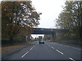
4
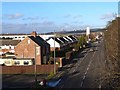
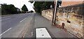
Durham Road, South Pelaw
The A167 passes beneath the Consett and Sunderland Railway Path. The Angel of the North giant sculpture Image can be seen on the skyline just to the right of the street light.
Image: © Oliver Dixon
Taken: 8 Jan 2014
0.23 miles
5
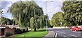
Weeping willow on verge on west side of Durham Road
Image: © Luke Shaw
Taken: 17 Sep 2022
0.23 miles
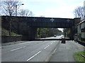
7
A167 passing under C2C cycle route on old railway
Image: © Colin Pyle
Taken: 3 Nov 2015
0.23 miles
8
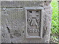
Ordnance Survey Flush Bracket 10924
This can be found on the wall of a former railway bridge in Durham Road, Birtley.
For more detail see : http://www.bench-marks.org.uk/bm22076
Image: © Peter Wood
Taken: 18 Jul 2015
0.23 miles
9
Looking north along A167 (Durham Road) opposite Pelaw Grange Court
There is a GPO cable marker against the wall about 2 feet on the near side of the telephone pole
Image: © Roger Templeman
Taken: 17 Sep 2022
0.23 miles
10
Benchmark on bridge wall on west side of Durham Road
Ordnance Survey flush bracket benchmark (serial number 10924) levelled at 33.443m above Newlyn Datum in 1961 and verified in 1983
Image: © Roger Templeman
Taken: 17 Sep 2022
0.23 miles