IMAGES TAKEN NEAR TO
Albert Street, CHESTER LE STREET, DH3 3DR
Introduction
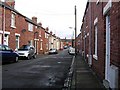
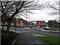
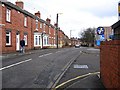
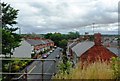
This page details the photographs taken nearby to Albert Street, DH3 3DR by members of the Geograph project.
The Geograph project started in 2005 with the aim of publishing, organising and preserving representative images for every square kilometre of Great Britain, Ireland and the Isle of Man.

There are currently over 7.5m images from over14,400 individuals and you can help contribute to the project by visiting https://www.geograph.org.uk
Image Map
Images are licensed for reuse under creativecommons.org/licenses/by-sa/2.0
Notes
- Clicking on the map will re-center to the selected point.
- The higher the marker number, the further away the image location is from the centre of the postcode.
Image Listing (82 Images Found)
Images are licensed for reuse under creativecommons.org/licenses/by-sa/2.0
Image
Details
Distance
6
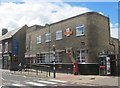
Chester-le Street Post Office
One of only two bearing the Royal Emblem of King Edward VIII
see http://en.wikipedia.org/wiki/Chester-le-Street
Image: © Peter Robinson
Taken: 11 Aug 2013
0.08 miles

9
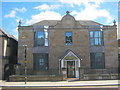
The Grove in Chester-le-Street
Offices for Durham Aged Mineworkers Homes Association
Image: © Peter Robinson
Taken: 11 Aug 2013
0.09 miles
10
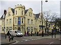
Lambton Arms Public House Chester-le-Street
Image: © rob bishop
Taken: 25 Feb 2006
0.11 miles