IMAGES TAKEN NEAR TO
Fell Bank, CHESTER LE STREET, DH3 2SS
Introduction
This page details the photographs taken nearby to Fell Bank, DH3 2SS by members of the Geograph project.
The Geograph project started in 2005 with the aim of publishing, organising and preserving representative images for every square kilometre of Great Britain, Ireland and the Isle of Man.

There are currently over 7.5m images from over14,400 individuals and you can help contribute to the project by visiting https://www.geograph.org.uk
Image Map
Images are licensed for reuse under creativecommons.org/licenses/by-sa/2.0
Notes
- Clicking on the map will re-center to the selected point.
- The higher the marker number, the further away the image location is from the centre of the postcode.
Image Listing (5 Images Found)
Images are licensed for reuse under creativecommons.org/licenses/by-sa/2.0
Image
Details
Distance
3
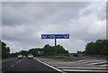
Junction 65, A1(M)
The last junction on the A1(M) before it reverts to the A1.
Image: © N Chadwick
Taken: 29 May 2011
0.18 miles
4
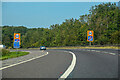
Birtley : A1(M)
Leaving the A1(M) at Junction 65.
Image: © Lewis Clarke
Taken: 21 Sep 2020
0.23 miles
5
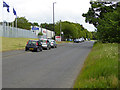
Volvo bus and Truck Centre
On Crowther Road at the west side of Washington. Pity they can't find space for parking for their own employees and visitors.
Image: © Oliver Dixon
Taken: 19 Jun 2015
0.24 miles