IMAGES TAKEN NEAR TO
Birtley Lane, CHESTER LE STREET, DH3 2LR
Introduction
This page details the photographs taken nearby to Birtley Lane, DH3 2LR by members of the Geograph project.
The Geograph project started in 2005 with the aim of publishing, organising and preserving representative images for every square kilometre of Great Britain, Ireland and the Isle of Man.

There are currently over 7.5m images from over14,400 individuals and you can help contribute to the project by visiting https://www.geograph.org.uk
Image Map
Images are licensed for reuse under creativecommons.org/licenses/by-sa/2.0
Notes
- Clicking on the map will re-center to the selected point.
- The higher the marker number, the further away the image location is from the centre of the postcode.
Image Listing (7 Images Found)
Images are licensed for reuse under creativecommons.org/licenses/by-sa/2.0
Image
Details
Distance
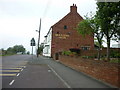
2
St John The Evangelist
The view of the Church on Birtley Lane, Birtley.
Image: © Gordon Griffiths
Taken: 5 Dec 2021
0.23 miles
3
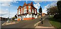
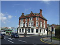
The William IV Hotel at Durham Road / Harras Bank
A'la Turka, Turkish Cuisine restaurant
Image: © Luke Shaw
Taken: 17 Sep 2022
0.24 miles
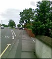
4
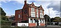
The William IV Hotel, A'la Turka, east side of Durham Road
Ordnance Survey documents indicate that a benchmark levelled at 34.336m above Newlyn Datum was verified in 1983 on the near corner of the hotel: the corner now has a pebbledash coating
Image: © Roger Templeman
Taken: 17 Sep 2022
0.24 miles
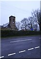
7
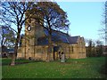
St John The Evangelist Church, Birtley
Image: © Bill Henderson
Taken: 14 Nov 2007
0.25 miles