IMAGES TAKEN NEAR TO
Dene Court, CHESTER LE STREET, DH3 1QH
Introduction
This page details the photographs taken nearby to Dene Court, DH3 1QH by members of the Geograph project.
The Geograph project started in 2005 with the aim of publishing, organising and preserving representative images for every square kilometre of Great Britain, Ireland and the Isle of Man.

There are currently over 7.5m images from over14,400 individuals and you can help contribute to the project by visiting https://www.geograph.org.uk
Image Map
Images are licensed for reuse under creativecommons.org/licenses/by-sa/2.0
Notes
- Clicking on the map will re-center to the selected point.
- The higher the marker number, the further away the image location is from the centre of the postcode.
Image Listing (19 Images Found)
Images are licensed for reuse under creativecommons.org/licenses/by-sa/2.0
Image
Details
Distance
1
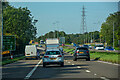
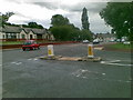
Birtley : A1
Looking north along the A1.
Image: © Lewis Clarke
Taken: 21 Sep 2020
0.10 miles
2
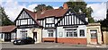
Coach and Horses on east side of Newcastle Bank
Image: © Roger Templeman
Taken: 17 Sep 2022
0.11 miles
3
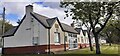
Joseph Hopper Terrace on NE side of A167
Houses named after the founder of the Durham Aged Mineworkers Homes Association. The stone plaque includes 1899 date.
Image: © Luke Shaw
Taken: 17 Sep 2022
0.12 miles
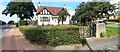
4
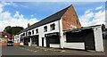
Shops on east side of Newcastle Bank
Image: © Roger Templeman
Taken: 17 Sep 2022
0.13 miles
6
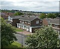
Houses on Crathie
Seen from the footbridge over the A1.
Image: © Oliver Dixon
Taken: 14 Jul 2021
0.15 miles
7
Long Bank
A road now cut off since the A1 Birtley bypass was upgraded to a motorway. Here it leaves the older A1 route through Birtley.
Image: © Richard Webb
Taken: 18 Jun 2013
0.15 miles
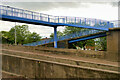
8
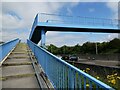
Footbridge over the A1
The steps incorporate a wheeling ramp, an aid to cyclists of somewhat dubious value.
Image: © Oliver Dixon
Taken: 14 Jul 2021
0.15 miles
10
#2 Long Bank, The Cottage at Newcastle Bank (A167) junction
Ordnance Survey records indicate that a benchmark levelled at 56.781m above Newlyn Datum was verified in 1962 1.5m left of the metal gate: the mark is probably still there hidden in the hedge
Image: © Roger Templeman
Taken: 17 Sep 2022
0.16 miles