IMAGES TAKEN NEAR TO
Valley View, CHESTER LE STREET, DH3 1PN
Introduction
This page details the photographs taken nearby to Valley View, DH3 1PN by members of the Geograph project.
The Geograph project started in 2005 with the aim of publishing, organising and preserving representative images for every square kilometre of Great Britain, Ireland and the Isle of Man.

There are currently over 7.5m images from over14,400 individuals and you can help contribute to the project by visiting https://www.geograph.org.uk
Image Map (Loading...)


Getting Data...Please wait
Leaflet Map data © OpenStreetMap
Images are licensed for reuse under creativecommons.org/licenses/by-sa/2.0
Notes
- Clicking on the map will re-center to the selected point.
- The higher the marker number, the further away the image location is from the centre of the postcode.
Image Listing (20 Images Found)
Images are licensed for reuse under creativecommons.org/licenses/by-sa/2.0
Image
Details
Distance
1
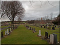
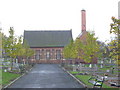
Birtley Cemetery
Birtley is a small town within the boundary of the larger town, Gateshead, a metropolitan borough. Birtley's crematorium is on the same site as the cemetery, being the brick-built building with the tell-tale chimney.
Image: © Trevor Littlewood
Taken: 22 Feb 2012
0.07 miles
4
Bowes Railway Path at Birtley
Bowes Railway was originally a colliery railway built to carry coal from the pits at Dipton to the Tyne at Jarrow. The earliest section was designed by George Stephenson and opened on 17 January 1826, making it one of the world's first modern railways. The railway remained virtually intact until 1968. Between 1968 and 1974, most of the line was closed.
The path following the line of the railway has now been designated as Regional Route 11 of the National Cycle Network. The path sustained severe storm damage in 2012 and is due to be repaired and upgraded. The path is also designated as part of the Great North Forest Heritage Trail.
Image: © Oliver Dixon
Taken: 8 Jan 2014
0.13 miles
5
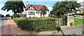
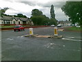
#2 Long Bank, The Cottage at Newcastle Bank (A167) junction
Ordnance Survey records indicate that a benchmark levelled at 56.781m above Newlyn Datum was verified in 1962 1.5m left of the metal gate: the mark is probably still there hidden in the hedge
Image: © Roger Templeman
Taken: 17 Sep 2022
0.14 miles
6
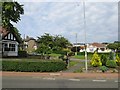
Long Bank
A road now cut off since the A1 Birtley bypass was upgraded to a motorway. Here it leaves the older A1 route through Birtley.
Image: © Richard Webb
Taken: 18 Jun 2013
0.14 miles
7
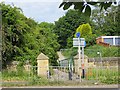
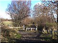
Bowes Railway access
A very rough former railway runs under the old A1 here.
Image: © Richard Webb
Taken: 18 Jun 2013
0.15 miles
8
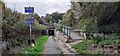
Bowes Railway Path approaching bridge under Newcastle Bank
Image: © Roger Templeman
Taken: 17 Sep 2022
0.15 miles
9
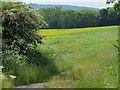
Oilseed rape, Long Acre
Beside the Bowes Railway and the Great North Road.
Image: © Richard Webb
Taken: 18 Jun 2013
0.15 miles
10
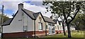
Joseph Hopper Terrace on NE side of A167
Houses named after the founder of the Durham Aged Mineworkers Homes Association. The stone plaque includes 1899 date.
Image: © Luke Shaw
Taken: 17 Sep 2022
0.15 miles