IMAGES TAKEN NEAR TO
Elisabeth Avenue, CHESTER LE STREET, DH3 1JA
Introduction
This page details the photographs taken nearby to Elisabeth Avenue, DH3 1JA by members of the Geograph project.
The Geograph project started in 2005 with the aim of publishing, organising and preserving representative images for every square kilometre of Great Britain, Ireland and the Isle of Man.

There are currently over 7.5m images from over14,400 individuals and you can help contribute to the project by visiting https://www.geograph.org.uk
Image Map
Images are licensed for reuse under creativecommons.org/licenses/by-sa/2.0
Notes
- Clicking on the map will re-center to the selected point.
- The higher the marker number, the further away the image location is from the centre of the postcode.
Image Listing (19 Images Found)
Images are licensed for reuse under creativecommons.org/licenses/by-sa/2.0
Image
Details
Distance
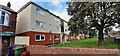
1
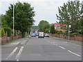
Ravensworth Road, Birtley
Junction with Edward Road.
Image: © Richard Webb
Taken: 18 Jun 2013
0.02 miles
2
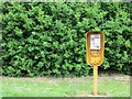
Telephone box, Ravensworth Road
An all but unprotected replacement for a traditional box, or additional public telephone. These were particularly popular in the late 1970s and I doubt many of them survive.
The outline of the older deeper telephone can be seen. These were grey and had two coin slots one for a 2p coin and the other for a 10p coin.
Image: © Richard Webb
Taken: 18 Jun 2013
0.06 miles
3
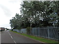
Mary Avenue, Birtley
White Poplar trees at Mary Avenue, Birtley
Image: © john durkin
Taken: 8 Aug 2019
0.14 miles
4
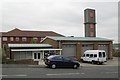
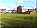
Birtley old fire station
Birtley old fire station, Edward Road, Birtley, Chester-le-Street, Tyne & Wear, now used as a boxing club
Image: © Kevin Hale
Taken: 4 Jun 2009
0.15 miles
5
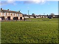
Open space beside Mary Avenue, Birtley
A solitary house remains standing out in the middle of the open space.
Image: © Oliver Dixon
Taken: 8 Jan 2014
0.17 miles
7
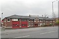
Birtley fire station
Birtley fire station, Durham Road, Birtley, Tyne & Wear
Image: © Kevin Hale
Taken: 26 Nov 2006
0.17 miles
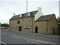
8
Ridgeway flats on west side of Durham Road
Ordnance Survey documents indicate that a benchmark levelled at 49.433m above Newlyn Datum was verified in 1962 on the near corner of flats here
Image: © Roger Templeman
Taken: 17 Sep 2022
0.18 miles
9
Lotus Leaf, Chinese restaurant and takeaway, on east side of Durham Road
Image: © Luke Shaw
Taken: 17 Sep 2022
0.19 miles
10
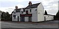
The Three Tuns, a Sam Smith's pub in Birtley
Image: © Ian S
Taken: 23 Apr 2011
0.19 miles