IMAGES TAKEN NEAR TO
Highridge, CHESTER LE STREET, DH3 1BD
Introduction
This page details the photographs taken nearby to Highridge, DH3 1BD by members of the Geograph project.
The Geograph project started in 2005 with the aim of publishing, organising and preserving representative images for every square kilometre of Great Britain, Ireland and the Isle of Man.

There are currently over 7.5m images from over14,400 individuals and you can help contribute to the project by visiting https://www.geograph.org.uk
Image Map
Images are licensed for reuse under creativecommons.org/licenses/by-sa/2.0
Notes
- Clicking on the map will re-center to the selected point.
- The higher the marker number, the further away the image location is from the centre of the postcode.
Image Listing (25 Images Found)
Images are licensed for reuse under creativecommons.org/licenses/by-sa/2.0
Image
Details
Distance
1
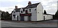
Lotus Leaf, Chinese restaurant and takeaway, on east side of Durham Road
Image: © Luke Shaw
Taken: 17 Sep 2022
0.19 miles
2
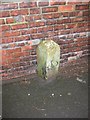
Old Milestone by the A167, Durham Road, Birtley
Carved stone post by the A167, in parish of BIRTLEY (GATESHEAD District), Durham Road, opposite Fire station, in pavement by brick wall, on East side of road. G/D stone, erected by the Durham & Tyne Bridge turnpike trust in the 19th century.
Inscription once read:- : (G / 5) : : (D /7) :
(To Gateshead and Durham)
Milestone Society National ID: DU_GHDH05.
Image: © Mike Rayner
Taken: 4 Mar 2016
0.20 miles
3
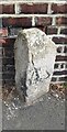
Old milestone on east side of Durham Road
The Ordnance Survey 1888-1913 6" Map records that the milestone indicated Newcastle 5, Durham 9
Image: © Roger Templeman
Taken: 17 Sep 2022
0.20 miles
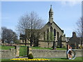
4
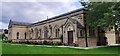
St Joseph's Church on north side of Birtley Lane
Image: © Roger Templeman
Taken: 17 Sep 2022
0.20 miles
5
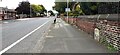
Looking north along Durham Road (A167) opposite Birtley Fire Station
There is a milestone Image against the wall at the right hand side of the road
Image: © Roger Templeman
Taken: 17 Sep 2022
0.20 miles
6
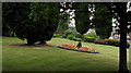
Public Garden in Birtley
A small area of grass, trees and flower beds on the east side of the A167, north of the shopping centre in Birtley, a district of Gateshead
Image: © Trevor Littlewood
Taken: 14 Jul 2010
0.21 miles
7
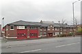
Birtley fire station
Birtley fire station, Durham Road, Birtley, Tyne & Wear
Image: © Kevin Hale
Taken: 26 Nov 2006
0.21 miles
8
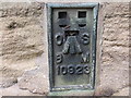
Ordnance Survey Flush Bracket 10923
This can be found on the wall of St Joseph's Church in Birtley.
For more detail see : http://www.bench-marks.org.uk/bm22075
Image: © Peter Wood
Taken: 18 Jul 2015
0.21 miles
9
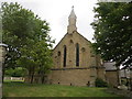
The Church of St Joseph at Birtley
Viewed from the west.
Image: © Peter Wood
Taken: 18 Jul 2015
0.21 miles