IMAGES TAKEN NEAR TO
Gair Court, CHESTER LE STREET, DH2 3QY
Introduction
This page details the photographs taken nearby to Gair Court, DH2 3QY by members of the Geograph project.
The Geograph project started in 2005 with the aim of publishing, organising and preserving representative images for every square kilometre of Great Britain, Ireland and the Isle of Man.

There are currently over 7.5m images from over14,400 individuals and you can help contribute to the project by visiting https://www.geograph.org.uk
Image Map
Images are licensed for reuse under creativecommons.org/licenses/by-sa/2.0
Notes
- Clicking on the map will re-center to the selected point.
- The higher the marker number, the further away the image location is from the centre of the postcode.
Image Listing (30 Images Found)
Images are licensed for reuse under creativecommons.org/licenses/by-sa/2.0
Image
Details
Distance
2
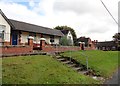
Aged Miners Homes, Nettlesworth
This terrace is on Park View, the main street through the village. The present village of Nettlesworth was created as a mining community in the 19th century. Aged Miners Homes were a feature of mining villages in County Durham, mostly built in the first half of the 20th century. These ones date from 1926.
Image: © Robert Graham
Taken: 23 Sep 2019
0.03 miles
3
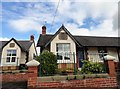
Plaque on the Aged Miners Homes at Nettlesworth
The plaque states that these were built in 1926, the year of the great strike. Nettlesworth is a former mining village, and these are typical of such villages in County Durham.
Image: © Robert Graham
Taken: 23 Sep 2019
0.04 miles
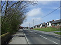
4
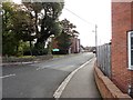
Road to Kimblesworth
From the neighbouring village of Nettlesworth, at the junction on Park View. These two little ex mining villages are of 19th origin, although they do have medieval roots.
Image: © Robert Graham
Taken: 23 Sep 2019
0.06 miles
5
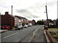
Main street in Kimblesworth
This is a view looking south along Cedar Avenue, the main road through the village. Kimblesworth is one of a group of former colliery villages to the north of Durham city, mostly created in the second half of the 19th century with the expansion of the mining industry. The old village terraced streets in this village were mostly demolished in the 1950's and 60's and replaced by the modern housing seen here.
Image: © Robert Graham
Taken: 23 Sep 2019
0.08 miles
6
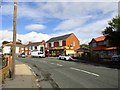
Shops on Cedar Avenue, Kimblesworth
Looking north in the centre of this little ex-mining village.
Image: © Robert Graham
Taken: 23 Sep 2019
0.08 miles
7
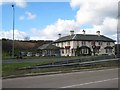
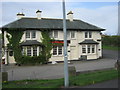
Red Lion, Plawsworth
Road house on the A167 between Durham and Chester-le-Street.
Image: © Oliver Dixon
Taken: 2 Mar 2007
0.12 miles
8
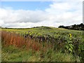
Sunflowers at Plawsworth
A rather surprising find of a field of Sunflowers beside the path leading from Plawsworth Gate to Nettlesworth.
Image: © Robert Graham
Taken: 23 Sep 2019
0.12 miles
9
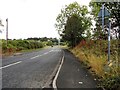
Road leading to the A167 from Nettlesworth
This road, the B6312, leads from the village to the main A167. The junction can be seen at the end of the road here, with the village of Plawsworth across the other side.
Image: © Robert Graham
Taken: 23 Sep 2019
0.12 miles