IMAGES TAKEN NEAR TO
The Firs, CHESTER LE STREET, DH2 3NX
Introduction
This page details the photographs taken nearby to The Firs, DH2 3NX by members of the Geograph project.
The Geograph project started in 2005 with the aim of publishing, organising and preserving representative images for every square kilometre of Great Britain, Ireland and the Isle of Man.

There are currently over 7.5m images from over14,400 individuals and you can help contribute to the project by visiting https://www.geograph.org.uk
Image Map
Images are licensed for reuse under creativecommons.org/licenses/by-sa/2.0
Notes
- Clicking on the map will re-center to the selected point.
- The higher the marker number, the further away the image location is from the centre of the postcode.
Image Listing (17 Images Found)
Images are licensed for reuse under creativecommons.org/licenses/by-sa/2.0
Image
Details
Distance
1
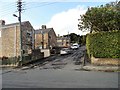
The Firs, Kimblesworth
A rustic name for a not-very-rustic housing development.
Image: © Oliver Dixon
Taken: 2 Mar 2007
0.01 miles
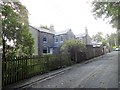
2
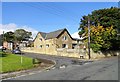
The Old School, Kimblesworth
This was built in 1878, but is no longer a school. I believe it is now a guest house.
Image: © Robert Graham
Taken: 23 Sep 2019
0.02 miles
3
South end of Cedar Avenue in Kimblesworth
These modern houses replaced the original Victorian miners terraces in the late 20th century.
Image: © Robert Graham
Taken: 23 Sep 2019
0.05 miles
4
Old terraces at Kimblesworth
This is East Parade, on the south end of the village. The mining village of Kimblesworth was established in the late 19th century. Most of the old terraced housing was demolished in the 1950's and 60's, but these terraces were of better quality as they were colliery officials houses, and were spared.
Image: © Robert Graham
Taken: 23 Sep 2019
0.06 miles
5
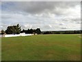
View across the cricket field at Kimblesworth
The village cricket field is in a very nice location, with views across the countryside to the east.
Image: © Robert Graham
Taken: 23 Sep 2019
0.08 miles
6
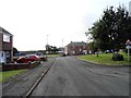
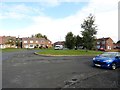
South end of Cedar Avenue
This road runs south through this small ex mining village to the roundabout at the bottom of the street here.
Image: © Robert Graham
Taken: 23 Sep 2019
0.08 miles
7
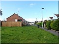
Hawthorn Close, Kimblesworth
This street is typical of the council built bungalows and houses which replaced the original miners terraced rows in the village in the later 20th century. The village had been mainly created in the late 19th century for the pitmen in the local mines.
Image: © Robert Graham
Taken: 23 Sep 2019
0.15 miles
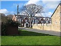
8
Kimblesworth House
This short street, right at the south end of the village, consists of former colliery officials houses. The first one is Kimblesworth House, and was the home of the colliery manager. The pit was behind these houses, and closed in 1967.
Image: © Robert Graham
Taken: 23 Sep 2019
0.15 miles
9
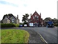
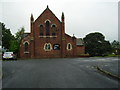
Parish Church at Kimblesworth
This is St Philip and St Paul's church, opened in 1893 to serve the mining village which had grown up here in the late 19th century. Previously, Kimblesworth had been a small farming community. There seems to be some building work in progress at the moment.
Image: © Robert Graham
Taken: 23 Sep 2019
0.16 miles