IMAGES TAKEN NEAR TO
Ripon Terrace, CHESTER LE STREET, DH2 3NR
Introduction
This page details the photographs taken nearby to Ripon Terrace, DH2 3NR by members of the Geograph project.
The Geograph project started in 2005 with the aim of publishing, organising and preserving representative images for every square kilometre of Great Britain, Ireland and the Isle of Man.

There are currently over 7.5m images from over14,400 individuals and you can help contribute to the project by visiting https://www.geograph.org.uk
Image Map (Loading...)


Getting Data...Please wait
Leaflet Map data © OpenStreetMap
Images are licensed for reuse under creativecommons.org/licenses/by-sa/2.0
Notes
- Clicking on the map will re-center to the selected point.
- The higher the marker number, the further away the image location is from the centre of the postcode.
Image Listing (35 Images Found)
Images are licensed for reuse under creativecommons.org/licenses/by-sa/2.0
Image
Details
Distance
1
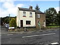
Houses at Plawsworth Gate
These houses are in a very noisy spot, right beside the busy A167. This road used to be even busier, when it was the Great North Road, prior to the opening of the A1M Durham Motorway. The name comes from the time when there was a tollgate here.
Image: © Robert Graham
Taken: 23 Sep 2019
0.03 miles
2

Looking down Mill lane, Plawsworth
View west to the houses on the A167. These form a detached part of the village known as Plawsworth Gate.
Image: © Robert Graham
Taken: 23 Sep 2019
0.04 miles
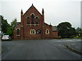
3
Kimblesworth Parish Church
St Philip and St James Church was constructed in 1893 in the former pit village of Kimblesworth. There was an earlier church in the medieval village of Kimblesworth which was abandoned in the sixteenth century. It is said that the font is from the old church. It are a traditional Anglican community situated on the edge of Kimblesworth village which is about 3.5 miles from Durham City. The parish includes the villages of Nettlesworth, Plawsworth and Kimblesworth and stretches from the River Wear to the edge of Sacriston
Image: © Colin Kinnear
Taken: 2 Jan 2023
0.08 miles
5
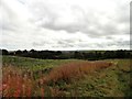
View from the field path at Plawsworth Gate
This path runs a short distance through the fields west of Plawsworth Gate to Nettlesworth. There is a wide view to the east over the countryside between Durham and Chester-Le-Street. Note the Sunflowers on the left; an unusual field crop in this part of the world.
Image: © Robert Graham
Taken: 23 Sep 2019
0.09 miles
6
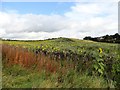
Sunflowers at Plawsworth
A rather surprising find of a field of Sunflowers beside the path leading from Plawsworth Gate to Nettlesworth.
Image: © Robert Graham
Taken: 23 Sep 2019
0.09 miles
7
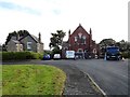
Parish Church at Kimblesworth
This is St Philip and St Paul's church, opened in 1893 to serve the mining village which had grown up here in the late 19th century. Previously, Kimblesworth had been a small farming community. There seems to be some building work in progress at the moment.
Image: © Robert Graham
Taken: 23 Sep 2019
0.09 miles
8
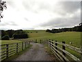
Fields beside Mill Lane
At Plawsworth. Mill lane is a little way south of the rest of the village. There used to be a mill here, but no longer. The track leads to a sewage works.
Image: © Robert Graham
Taken: 23 Sep 2019
0.16 miles
9
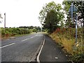
Road leading to the A167 from Nettlesworth
This road, the B6312, leads from the village to the main A167. The junction can be seen at the end of the road here, with the village of Plawsworth across the other side.
Image: © Robert Graham
Taken: 23 Sep 2019
0.16 miles
10
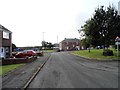
South end of Cedar Avenue
This road runs south through this small ex mining village to the roundabout at the bottom of the street here.
Image: © Robert Graham
Taken: 23 Sep 2019
0.17 miles