IMAGES TAKEN NEAR TO
Auckland, CHESTER LE STREET, DH2 2TY
Introduction
This page details the photographs taken nearby to Auckland, DH2 2TY by members of the Geograph project.
The Geograph project started in 2005 with the aim of publishing, organising and preserving representative images for every square kilometre of Great Britain, Ireland and the Isle of Man.

There are currently over 7.5m images from over14,400 individuals and you can help contribute to the project by visiting https://www.geograph.org.uk
Image Map
Images are licensed for reuse under creativecommons.org/licenses/by-sa/2.0
Notes
- Clicking on the map will re-center to the selected point.
- The higher the marker number, the further away the image location is from the centre of the postcode.
Image Listing (6 Images Found)
Images are licensed for reuse under creativecommons.org/licenses/by-sa/2.0
Image
Details
Distance
3
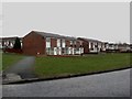
Houses on Netherton Close, Chester-le-Street
The backs of some of the houses on Netherton Close.
Image: © Graham Robson
Taken: 17 Mar 2018
0.23 miles
4
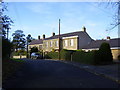
Houses in front of Hermitage School Chester le Street
Image: © P Glenwright
Taken: 12 Nov 2006
0.23 miles
5
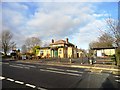
The Whitehills pub
Well known pub on Waldridge Road, Chester-le-Street.
Image: © Robert Graham
Taken: 28 Nov 2012
0.24 miles
6
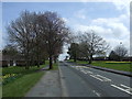
Waldridge Road heading east, Chester-le-Street
Image: © JThomas
Taken: 2 May 2013
0.24 miles