IMAGES TAKEN NEAR TO
Bernard Terrace, CHESTER LE STREET, DH2 2RD
Introduction
This page details the photographs taken nearby to Bernard Terrace, DH2 2RD by members of the Geograph project.
The Geograph project started in 2005 with the aim of publishing, organising and preserving representative images for every square kilometre of Great Britain, Ireland and the Isle of Man.

There are currently over 7.5m images from over14,400 individuals and you can help contribute to the project by visiting https://www.geograph.org.uk
Image Map
Images are licensed for reuse under creativecommons.org/licenses/by-sa/2.0
Notes
- Clicking on the map will re-center to the selected point.
- The higher the marker number, the further away the image location is from the centre of the postcode.
Image Listing (10 Images Found)
Images are licensed for reuse under creativecommons.org/licenses/by-sa/2.0
Image
Details
Distance
1
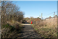
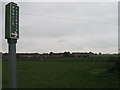
Consett & Sunderland Railway Path
The Consett & Sunderland Railway Path approaching Pelton from the south.
Image: © Trevor Littlewood
Taken: 8 Mar 2017
0.12 miles
4
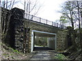
Bridge at Pelton Fell
This road bridge over the old Railway has been reinforced with new abutments.
Image: © Robert Graham
Taken: 6 Feb 2013
0.15 miles
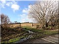
6
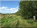
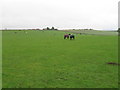
Field Edge
Field edge near Pelton House Farm Estate. This field was a part of Newfield Farm and has been allowed to grow unkempt awaiting development.
The round topped gatepost on the right was part of an occupation level crossing leading over the railway to Station Lane; the former railway is now the Consett and Sunderland Railway Path.
Image: © Adrian Taylor
Taken: 20 Aug 2020
0.18 miles
7
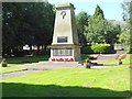
Pelton Fell War Memorial
Set in a well-kept park off Station Lane.
Image: © Oliver Dixon
Taken: 29 Aug 2016
0.22 miles
8
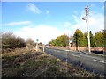
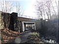
Minor road south of Pelton
This road runs alongside the old Railway Path from pelton Fell to Pelton village.
Image: © Robert Graham
Taken: 6 Feb 2013
0.22 miles
9
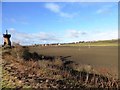
Monument beside the old railway
View north from the old railway path at Pelton Fell looking towards Pelton. The big structure on the left is some sort of industrial monument.
Image: © Robert Graham
Taken: 6 Feb 2013
0.24 miles
10
View of Newfield Farm
Looking west from the old railway south of Pelton. The farm buildings appear to be in a derelict state.
Image: © Robert Graham
Taken: 6 Feb 2013
0.25 miles