IMAGES TAKEN NEAR TO
Chester Burn Close, CHESTER LE STREET, DH2 2NZ
Introduction
This page details the photographs taken nearby to Chester Burn Close, DH2 2NZ by members of the Geograph project.
The Geograph project started in 2005 with the aim of publishing, organising and preserving representative images for every square kilometre of Great Britain, Ireland and the Isle of Man.

There are currently over 7.5m images from over14,400 individuals and you can help contribute to the project by visiting https://www.geograph.org.uk
Image Map
Images are licensed for reuse under creativecommons.org/licenses/by-sa/2.0
Notes
- Clicking on the map will re-center to the selected point.
- The higher the marker number, the further away the image location is from the centre of the postcode.
Image Listing (23 Images Found)
Images are licensed for reuse under creativecommons.org/licenses/by-sa/2.0
Image
Details
Distance
1
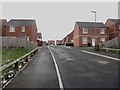
New housing development, Whitehill, Chester-le-Street
A modern housing development in the Whitehill area close to Chester-le-Street.
Image: © Graham Robson
Taken: 17 Mar 2018
0.06 miles
2
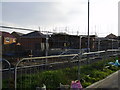
New house construction replacing the Whitehills estate Pelton Fell
Image: © P Glenwright
Taken: 12 Nov 2006
0.10 miles
3
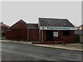
Pharmacy, Pelton Fell
A small pharmacy on the Pelton Fell estate on the western edge of Chester-le-Street.
Image: © Graham Robson
Taken: 17 Mar 2018
0.13 miles
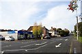
5
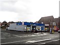
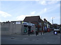
Convenience store and Post Office, Pelton Fell
A combined convenience store and post office on the main road in the centre of Pelton Fell.
Image: © Graham Robson
Taken: 17 Mar 2018
0.15 miles
6
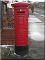
Postbox, Pelton Fell
The Georgian post box located outside the post office and convenience store on the main road through Pelton Fell.
Image: © Graham Robson
Taken: 17 Mar 2018
0.16 miles
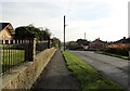
7
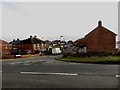
Valley Road, Pelton Fell
Looking across the main road to Valley Road, a residential street on the western edge of Pelton Fell.
Image: © Graham Robson
Taken: 17 Mar 2018
0.16 miles
8
Edwardian houses at Pelton Fell
This is Dunsany Terrace, on Bluehouse Bank. These were probably built in Edwardian times, before the First World War. Although Pelton Fell was a mining village, these don't look like miners houses. They may have been for colliery officials.
Image: © Robert Graham
Taken: 14 Oct 2019
0.17 miles
9
View down Bluehouse Bank
Looking west down the road, the main road through Pelton Fell to Chester le street.
Image: © Robert Graham
Taken: 14 Oct 2019
0.17 miles
10
Looking west along Pelton Fell Road
Towards the fell top up Bluehouse Bank.
Image: © Robert Graham
Taken: 14 Oct 2019
0.17 miles