IMAGES TAKEN NEAR TO
Wensley Close, CHESTER LE STREET, DH2 1SE
Introduction
This page details the photographs taken nearby to Wensley Close, DH2 1SE by members of the Geograph project.
The Geograph project started in 2005 with the aim of publishing, organising and preserving representative images for every square kilometre of Great Britain, Ireland and the Isle of Man.

There are currently over 7.5m images from over14,400 individuals and you can help contribute to the project by visiting https://www.geograph.org.uk
Image Map
Images are licensed for reuse under creativecommons.org/licenses/by-sa/2.0
Notes
- Clicking on the map will re-center to the selected point.
- The higher the marker number, the further away the image location is from the centre of the postcode.
Image Listing (8 Images Found)
Images are licensed for reuse under creativecommons.org/licenses/by-sa/2.0
Image
Details
Distance
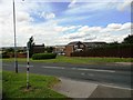
1
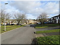
Ridmires Close at Ouston
Looking north-eastward.
Image: © Peter Wood
Taken: 16 Feb 2019
0.10 miles
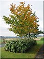
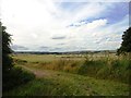
5
Start of the path to Perkinsville
This footpath leads over the fields from the SW side of Urpeth Grange housing estate.
Image: © Robert Graham
Taken: 31 Jul 2013
0.17 miles
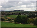
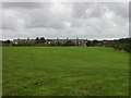
8
View west from the track north of Perkinsville
This path through the fields runs south from Urpeth to Perkinsville, Pelton. View to the west is over towards Beamish and Stanley.
Image: © Robert Graham
Taken: 31 Jul 2013
0.22 miles