IMAGES TAKEN NEAR TO
Tweed Close, CHESTER LE STREET, DH2 1ES
Introduction
This page details the photographs taken nearby to Tweed Close, DH2 1ES by members of the Geograph project.
The Geograph project started in 2005 with the aim of publishing, organising and preserving representative images for every square kilometre of Great Britain, Ireland and the Isle of Man.

There are currently over 7.5m images from over14,400 individuals and you can help contribute to the project by visiting https://www.geograph.org.uk
Image Map
Images are licensed for reuse under creativecommons.org/licenses/by-sa/2.0
Notes
- Clicking on the map will re-center to the selected point.
- The higher the marker number, the further away the image location is from the centre of the postcode.
Image Listing (18 Images Found)
Images are licensed for reuse under creativecommons.org/licenses/by-sa/2.0
Image
Details
Distance
4

Lyne Close joining Ouston Lane in Perkinsville
Looking eastward.
Image: © Peter Wood
Taken: 16 Feb 2019
0.11 miles
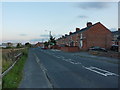
5
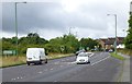
Approaching the Perkinsville roundabout
On the A693.
Image: © Russel Wills
Taken: 4 Sep 2016
0.15 miles
7

Allotment behind front street Perkinsville
Image: © P Glenwright
Taken: Unknown
0.19 miles
8
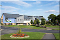
Multi-purpose building at Pelton
The building between the settlements of Pelton and Perkinsville in County Durham serves as a library, a medical centre and a pharmacy and has perhaps other uses too.
Image: © Trevor Littlewood
Taken: 30 Aug 2016
0.20 miles
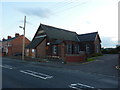
10
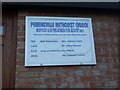
Perkinsville Methodist Church, Sign
Image: © Alexander P Kapp
Taken: 25 Aug 2011
0.20 miles