IMAGES TAKEN NEAR TO
Mossway, CHESTER LE STREET, DH2 1DL
Introduction
This page details the photographs taken nearby to Mossway, DH2 1DL by members of the Geograph project.
The Geograph project started in 2005 with the aim of publishing, organising and preserving representative images for every square kilometre of Great Britain, Ireland and the Isle of Man.

There are currently over 7.5m images from over14,400 individuals and you can help contribute to the project by visiting https://www.geograph.org.uk
Image Map
Images are licensed for reuse under creativecommons.org/licenses/by-sa/2.0
Notes
- Clicking on the map will re-center to the selected point.
- The higher the marker number, the further away the image location is from the centre of the postcode.
Image Listing (25 Images Found)
Images are licensed for reuse under creativecommons.org/licenses/by-sa/2.0
Image
Details
Distance


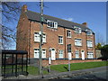


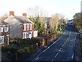
8
Houses on north side of Front Street
The two nearer buildings are pairs of semi-detached houses, the third is the Pelton District War Memorial Hall. The Consett & Sunderland Railway Path crosses the old railway bridge in shadow at the left side of the image.
Image: © Trevor Littlewood
Taken: 8 Mar 2017
0.14 miles
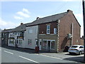
10
Front Street, Pelton
Seen from the Consett and Sunderland Railway Path.
Image: © Oliver Dixon
Taken: 8 Jan 2014
0.14 miles