IMAGES TAKEN NEAR TO
Sidegate, DURHAM, DH1 5SY
Introduction
This page details the photographs taken nearby to Sidegate, DH1 5SY by members of the Geograph project.
The Geograph project started in 2005 with the aim of publishing, organising and preserving representative images for every square kilometre of Great Britain, Ireland and the Isle of Man.

There are currently over 7.5m images from over14,400 individuals and you can help contribute to the project by visiting https://www.geograph.org.uk
Image Map
Images are licensed for reuse under creativecommons.org/licenses/by-sa/2.0
Notes
- Clicking on the map will re-center to the selected point.
- The higher the marker number, the further away the image location is from the centre of the postcode.
Image Listing (264 Images Found)
Images are licensed for reuse under creativecommons.org/licenses/by-sa/2.0
Image
Details
Distance
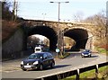
1
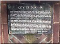
Notice about a well in Framwellgate, Durham City
On a bend of the A691 road under railway bridge
Image: © Barry Wood
Taken: 27 Jan 2008
0.02 miles
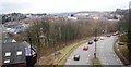
2
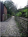
Sidegate, Durham City
For a fascinating account of this ancient part of the city see:
http://www.thisisthenortheast.co.uk/the_north_
east/history/echomemories/durham/105/2303705.html (follow the 'history' link and look for the article by David Simpson)
Image: © Alan Fearon
Taken: 7 Nov 2005
0.02 miles
3
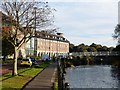
Radisson Hotel Durham
A new Build hotel on Framwelgate Waterside. Durham City
Image: © David Clark
Taken: 7 Oct 2014
0.06 miles
4
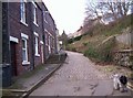
Sidegate, Durham City.
An old cobbled street
Image: © Barry Wood
Taken: 27 Jan 2008
0.06 miles
7
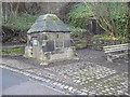
Well head at Framwellgate Peth, Durham
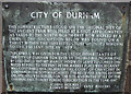
Built in 1450 rebuilt 1847 and restored 1959; resited from 165 yards to the north-east. The gift of Thomas Billingham to the city. Coursed squared sandstone. Rectangular plan with low diagonal buttresses; slot in east side; south side has rebates for door, now blocked and containing commemorative plaque giving history of well. Steeply-sloped coping 3 courses high.
Image: © Peter Robinson
Taken: 27 Feb 2011
0.07 miles
8
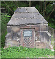
Old well head
This structure stood on the original site of the old Fram Well Head some yards to the NNE of its present position. For information, see also Image
Image: © Pauline E
Taken: 1 Jun 2013
0.07 miles
9
Plaque giving information about Fram Well Head
See also Image
Image: © Pauline E
Taken: 1 Jun 2013
0.07 miles
10
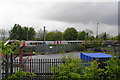
A train leaving Durham Station
The view on emerging from the woodland around the Jubilee Way.
Image: © Bill Boaden
Taken: 24 May 2013
0.08 miles