IMAGES TAKEN NEAR TO
Crossgate Moor, DURHAM, DH1 4TJ
Introduction
This page details the photographs taken nearby to DH1 4TJ by members of the Geograph project.
The Geograph project started in 2005 with the aim of publishing, organising and preserving representative images for every square kilometre of Great Britain, Ireland and the Isle of Man.

There are currently over 7.5m images from over14,400 individuals and you can help contribute to the project by visiting https://www.geograph.org.uk
Image Map (Loading...)


Getting Data...Please wait
Leaflet Map data © OpenStreetMap
Images are licensed for reuse under creativecommons.org/licenses/by-sa/2.0
Notes
- Clicking on the map will re-center to the selected point.
- The higher the marker number, the further away the image location is from the centre of the postcode.
Image Listing (15 Images Found)
Images are licensed for reuse under creativecommons.org/licenses/by-sa/2.0
Image
Details
Distance
1
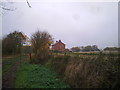
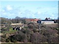
Bearpark Hall Farm
View of the farmhouse from the track from Stotgate Farm.
Image: © Robert Graham
Taken: 2 Nov 2011
0.01 miles
2
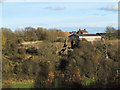
Ruins of Beaurepaire
The ruins of Beaurepaire, near to the village of Bearpark are seen here across the valley of the River Browney from the Lanchester Valley Railway Walk. The buildings of Bearpark Hall Farm lie beyond the ruins. (Note: for information on Beaurepaire, see - http://www.keystothepast.info/durhamcc/K2P.nsf/K2PDetail?readform&PRN=D1308 )
Image: © Trevor Littlewood
Taken: 17 Nov 2012
0.03 miles
3
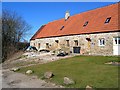
Bearpark Hall Farm: buildings being converted to cottages
Image: © Roger Smith
Taken: 2 Mar 2008
0.04 miles
4
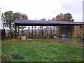
Old hay barn
Old steel hay barn at Bearpark Hall Farm.
Image: © Robert Graham
Taken: 2 Nov 2011
0.04 miles
5
Bearpark Hall Farm with ruins of Beau Repaire in the Foreground
Image: © Roger Smith
Taken: 2 Mar 2008
0.07 miles
6
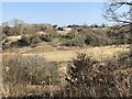
View to Bearpark Hall Farm
View across the Browney valley to Bearpark Hall Farm. Hidden on the hill in front of the farm are the ruins of Bearpark (Beaurepaire beautiful retreat) Priory - a medieval retirement residence for the Bishops of Durham.
Image: © David Robinson
Taken: 27 Mar 2022
0.08 miles
7
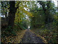
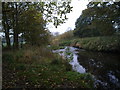
Lane leading down from Bearpark Hall
View down the lane leading from the farm to the river Browney. The trees are showing nice Autumn colours.
Image: © Robert Graham
Taken: 2 Nov 2011
0.10 miles
8

Ruins of Beaurepaire Prior's House
The ruins of a grand Prior's manor house attached to the Priory of Beaurepaire, dating from the 13th century. Subsequently destroyed by the Scots and rebuilt, but now a desolate ruin. http://www.collectbritain.co.uk/galleries/durham/object.cfm?uid=030KTOP00000012U044A0000 The name Beaurepaire has become corrupted to Bear Park and is also applied to the nearby former colliery village.
Image: © Oliver Dixon
Taken: 5 Nov 2006
0.14 miles
9
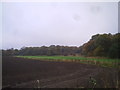
Riverside fields
Ploughed field beside the Browney, on a misty Autumn day.
Image: © Robert Graham
Taken: 2 Nov 2011
0.14 miles
10
View of the river Browney
This stretch between Bearpark and Witton Gilbert is tree lined most of the way and makes a very pleasant walk.
Image: © Robert Graham
Taken: 2 Nov 2011
0.19 miles