IMAGES TAKEN NEAR TO
Crossgate Moor, DURHAM, DH1 4TH
Introduction
This page details the photographs taken nearby to DH1 4TH by members of the Geograph project.
The Geograph project started in 2005 with the aim of publishing, organising and preserving representative images for every square kilometre of Great Britain, Ireland and the Isle of Man.

There are currently over 7.5m images from over14,400 individuals and you can help contribute to the project by visiting https://www.geograph.org.uk
Image Map
Images are licensed for reuse under creativecommons.org/licenses/by-sa/2.0
Notes
- Clicking on the map will re-center to the selected point.
- The higher the marker number, the further away the image location is from the centre of the postcode.
Image Listing (24 Images Found)
Images are licensed for reuse under creativecommons.org/licenses/by-sa/2.0
Image
Details
Distance
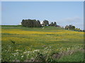
2
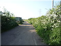
Farm track (footpath) near Moorsley Banks Farm
Looking north.
Image: © JThomas
Taken: 4 Jun 2016
0.05 miles
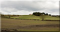
4
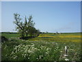
Grazing and hedgerow
Near Moorsley Banks Farm.
Image: © JThomas
Taken: 4 Jun 2016
0.07 miles
5
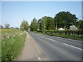
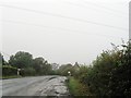
Minor road towards Durham
Heading east near Moorsley Banks Farm.
Image: © JThomas
Taken: 4 Jun 2016
0.07 miles
6
Two crows in a muddy field
One field on the western outskirts of Durham city is still very muddy following a particularly wet winter; those on the slope beyond the hedge however appear to be in a rather better state.
Image: © Trevor Littlewood
Taken: 30 Mar 2016
0.09 miles
7
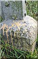
Ordnance Survey Rivet
This OS rivet can be found on the SW corner of the Pylon. It marks a point 87.685m above mean sea level.
Image: © Adrian Dust
Taken: 21 Sep 2018
0.10 miles
9
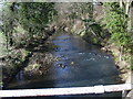
River Browney
The View from the Baxter Wood Farm Bridge.
Image: © Gordon Griffiths
Taken: 14 Mar 2008
0.17 miles
10
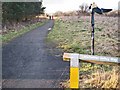
Lanchester Valley Path at Baxter Wood
The Lanchester Valley Path, one of the many paths in County Durham which follows the line of an old railway, forms part of National Cycle Network route 14. The Network milepost is of the "Welsh" design.
Image: © Oliver Dixon
Taken: 17 Feb 2007
0.17 miles